Lecture
This review is an attempt to summarize information on existing and planned to introduce satellite systems focused on the provision of radiotelephone services and data transmission. All the material, which turned out to be quite a lot, was divided into three parts: orbits and parameters, satellites and launch vehicles, ground stations. In the first part, the basic indicators of the orbits are determined, a classification of the systems is given, and the issues of choosing the parameters of non-geostationary orbital groupings are given in detail. The second part is devoted to spacecraft (SC), on-board transponders and means of launching the spacecraft into orbit. The third part deals with the principles of communication organization, describes the characteristics of ground stations and subscriber equipment, as well as technical and economic indicators of the systems.
It is known that the effectiveness of any communication system is ultimately determined by the range of services it provides to the user and its tariffs. Moreover, high technical and economic indicators of the system are determined, first of all, not by the manufacturing technology and design of ground stations (although they are undoubtedly important for the user), but by system-wide characteristics — guaranteed throughput, used by the frequency-orbital resource, structure and parameters of space and ground segments.
Satellite communication is significantly different from other types of radio communications - radio relay, tropospheric, ionospheric, cellular or trunked.
Thus, in radio relay communication systems, the length of a line largely depends on the presence of direct visibility between subscribers and the type of route (open, half-open, closed). In systems of over-the-horizon communication, the distance between stations is determined by the state of the troposphere or ionosphere, since the action of these systems is based on the effect of scattering of radio waves on irregularities in the troposphere (ionosphere) or reflections from the upper layers of the ionosphere.
The size of the service area of cellular and trunking systems depends on the height of the base station antenna. In satellite communications systems (SSS), the main indicators determining the size of such a zone, the quality of service, and the power of the radio lines are the type of the orbit and its characteristics.
The author proposes a classification of CAS, focused on the provision of radiotelephone services and data transmission, based on the following features.
The type of orbits used. According to this feature, all SSS are divided into two classes - systems with spacecraft (SC) in geostationary orbit (GEO) and non-geostationary orbit. In turn, non-geostationary orbits are divided into low-orbit (LEO), medium-altitude (MEO) and elliptical (HEO). In addition, low-orbit communication systems are divided by type of service provided into little LEO-based data transmission systems, big LEO radio telephone systems and mega LEO broadband communication systems (Super LEO is also used in the literature).
The system belongs to the service. According to the Radio Regulations, three basic services are distinguished - the fixed satellite service (FSS), the mobile satellite service (MSS) and the broadcasting satellite service (RCC).
System status It depends on the purpose of the system, the extent of coverage of the service area, location and accessories of ground stations. Depending on the status of the CAS, it can be divided into international (global and regional), national and departmental (the latter are not considered in this review).
Table 1. Systems using spacecraft on GEO-, MEO- and LEO-orbits |
|||
| Indicator | Geo | MEO | LEO |
| The height of the orbit, km | 36,000 | 5000-15 000 | 500-2000 |
| Number of spacecraft in the exhaust gas | 3 | 8-12 | 48-66 |
| Coverage area of one satellite (angle of view 50),% of the Earth’s surface | 34 | 25-28 | 3-7 |
| The residence time of the spacecraft in the area of visibility (per day) | 24 h | 1.5-2 hours | 10-15 min |
| Delay in the transmission of speech, ms | |||
| Regional connection | 500 | 80-130 | 20-70 |
| Global connectivity | 600 | 250-400 | 170-300 |
| Switching time, min | |||
| from one satellite to another | Not required | 50 | 8-10 |
| from one beam to another | 10-15 | 5-6 | 1.5-2.0 |
| Relative maximum Doppler shift | 610-8 | 66 10-6 | 6 (1.8-2.4) 10-5 |
| Angle of spacecraft visibility at the boundary of the service area, 0 | five | 15-25 | 10-15 |
Most of the existing CAS use the most advantageous geostationary orbit for satellite placement, the main advantages of which are the possibility of continuous round-the-clock communication in the global service area and the almost complete absence of frequency shift due to the Doppler effect.
Geostationary satellites, located at an altitude of about 36 thousand km and moving with the speed of rotation of the Earth, as if "hover" above a certain point on the earth's surface, which is located at the equator (the so-called sub-satellite point). In fact, the position of a geostationary spacecraft in orbit is not the same: it experiences a slight “drift” under the influence of a number of factors causing orbit degradation. The change in the position of the orbit for the year can reach 0.920. The main parameters that determine the angular separation between neighboring spacecraft are the spatial selectivity of the onboard and ground antennas, as well as the accuracy of the spacecraft in orbit.
Communication through the geostationary spacecraft does not have service interruptions due to the mutual movement of the satellite and the ground station, and the system of three satellites provides coverage of almost the entire earth's surface. The orbital resource of modern geostationary spacecraft is also quite high and is about 15 years (Table 1).
However, such systems have several disadvantages, the main of which is the signal delay. Satellites in geostationary orbits are optimal for radio and television broadcasting systems, where delays of 250 ms (in each direction) do not affect the quality characteristics of signals. Radiotelephone communication systems are more sensitive to delays, and since the total delay in this class of systems is about 600 ms (taking into account processing and switching time in terrestrial networks), even modern echo cancellation technology does not always allow for high quality communications. In the case of a “double jump” (retransmission via a ground station gateway), the delay becomes unacceptable for more than 20% of users.
The architecture of geostationary systems limits the ability to reuse selected frequency bands, and hence their spectral efficiency. The coverage area of geostationary spacecraft does not include high-latitude areas (above 76.50 N.N.S.), that is, truly global service is not guaranteed. It should also be noted that geostationary spacecraft can provide personal communication services only if the service areas they form on the Earth's surface are about the same as those formed by low-orbit satellites.
The rapid development of satellite communications, especially in the last decade, has led to the fact that in geostationary orbit it has become very "cramped" and problems have arisen with the deployment of new spacecraft. The fact is that, in accordance with existing international standards, the orbital separation between geostationary spacecraft must be at least 10. This means that no more than 360 satellites can be placed in orbit. As for the reduction of the angular separation between the spacecraft standing points in orbit, this is impossible at the current level of technology development due to mutual interference.
Satellites in medium-altitude orbits were the first to start developing companies traditionally producing geostationary spacecraft. Medium-altitude systems provide better-quality characteristics of servicing mobile subscribers than geostationary, since a large number of spacecraft are simultaneously in the user's field of view. Due to this, it is possible to increase the minimum angles of visibility of the spacecraft to 25-300.
Thus, the radio visibility of two satellites in the ICO system is provided for 95% of the daily time, and at least one of its spacecraft is visible at an angle of more than 300. And this, in turn, reduces the additional energy reserve of the radio link necessary to compensate for the propagation losses in near zone (in the presence of trees, buildings and other obstacles).
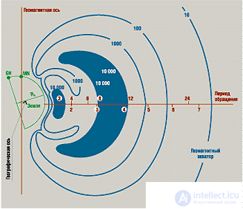
Fig. 1. Radiation levels in Van Allen zones: GN - geographical north; MN - magnetic north; R / R3 - relative distance, where R3 (radius of the Earth) = 6371 km, R - height |
However, when choosing the location of a non-geostationary orbital grouping (OG), it is necessary to take into account natural limitations - these are spatial belts of charged particles trapped by the Earth’s magnetic field, the so-called Van Allen radiation belts (Fig. 1). The first stable belt of high radiation begins at an altitude of 1.5 thousand kilometers and extends to several thousand kilometers, its “span” is about 300 on either side of the equator. The second zone of equally high intensity (10 thousand imp. / S) is located at altitudes from 13 to 19 thousand km, covering about 500 on either side of the equator.
The route of medium-altitude satellites passes between the first and second Van Allen belts, that is, at an altitude of 5 to 15 thousand km. The service area of each spacecraft is significantly smaller than that of the geostationary, therefore, for global coverage with single coverage of the most populated areas of the globe and navigable water areas, it is necessary to create an OG of 8-12 satellites. The total delay of the signal when communicating via medium-height satellites is not more than 130 ms, which makes it possible to use them for radiotelephone communication.
Thus, medium-altitude satellites gain from geostationary in terms of energy performance, but lose to them in terms of the duration of spacecraft staying in the radio visibility range of ground stations (1.5—2 hours).
Что же касается орбитального ресурса средневысотных КА, то он лишь незначительно меньше, чем у геостационарных. Период обращения спутника вокруг Земли для средневысотных круговых орбит составляет около 6 ч (при высоте 10 350 км), из которых в тени Земли КА находится лишь несколько минут. Это позволяет значительно упростить технологические решения, используемые в бортовой системе электропитания, и, в конечном счете, довести срок службы КА до 12—15 лет.
Системы со средневысотными КА обеспечивают лучшие, чем GEO-КА, характеристики обслуживания абонентов благодаря следующим особенностям. Они имеют большие углы радиовидимости, в зоне радиовидимости находится большее число спутников, а задержка при проведении сеансов связи составляет максимум 130 мс.
Структура систем на средневысотных орбитах (ICO, Spaceway NGSO, "Ростелесат") различается незначительно. Во всех этих системах орбитальная группировка создается примерно на одной и той же высоте (10 352—10 355 км) со сходными параметрами орбит (см. табл. 1).
В зависимости от величины наклонения плоскости орбиты относительно плоскости экватора различают низкие экваториальные (наклонение 00), полярные (наклонение 900) и наклонные орбиты. Системы с низкими наклонными и полярными орбитами существуют уже около 30 лет и применяются в основном для научно-исследовательских целей, дистанционного зондирования, навигации, метеорологических наблюдений, фотографирования поверхности Земли. Для организации мобильной и персональной связи эти системы стали использоваться только в последние 5—7 лет. Сегодня наиболее интенсивно осваиваются низкие наклонные и полярные орбиты высотой 700—1500 км, а также экваториальные высотой 2 тыс. км.
Спутники на низких орбитах обладают значительными преимуществами перед другими КА по энергетическим характеристикам, но проигрывают им в продолжительности сеансов связи и времени активного существования КА. Если период обращения спутника составляет 100 мин, то в среднем 30% времени он находится на теневой стороне Земли. Аккумуляторные бортовые батареи испытывают приблизительно 5 тыс. циклов зарядки/разрядки в год, вследствие чего срок их службы, как правило, не превышает 5—8 лет.
Выбор диапазона высот от 700 до 2 тыс. км для низкоорбитальных систем неслучаен.
С одной стороны, на орбитах высотой менее 700 км плотность атмосферы относительно высока, что вызывает коле***ния эксцентриситета и деградацию орбиты (постепенное снижение высоты апогея). Кроме того, уменьшение высоты орбиты приводит к увеличению числа штатных маневров для сохранения заданной орбиты, а следовательно, к повышению расхода топлива.
С другой стороны, на орбитах выше 1,5 тыс. км, где располагается первый радиационный пояс Ван-Аллена, длительная работа электронной бортовой аппаратуры практически невозможна, если не использовать специальных методов защиты от радиационного излучения. Применение же этих методов ведет к существенному усложнению бортовой аппаратуры и увеличению массы КА.
Однако чем меньше высота орбиты, тем меньше мгновенная зона обслуживания, а следовательно, для глобального охвата требуется значительно большее количество спутников. Если низкоорбитальная система должна обеспечить глобальную связь с непрерывным обслуживанием, то необходимо, чтобы в орбитальную группировку входило не менее 48 КА. Период обращения спутника на этих орбитах составляет от 90 мин до 2 ч, а максимальное время пребывания КА в зоне радиовидимости не превышает 10—15 мин (см. табл. 1).
Таблица 2. Типы эллиптических орбит и их основные параметры |
|||
| Тип орбиты | Высота апогея*, км | Период обращения, ч | Число витков в сутки |
| Borealis | 7840 | 3 | eight |
| Archimedes | 28000 | eight | 3 |
| "Молния" | 40,000 | 12 | 2 |
| "Тундра" | 71,000 | 24 | one |
| * Высота перигея для всех указанных типов орбит составляет 500 км | |||
Таблица 3. Крупнейшие орбитальные группировки международных организаций |
|||||
| Indicator | Arabsat* (1972, 21) | Еutelsat (1977, 47) | Inmarsat (1979, 79) | Intelsat (1964, 132) | Intersputnik (1971, 26) |
| Статус системы | Региональная | Региональная | Глобальная | Глобальная | Глобальная |
| Основной регион обслуживания | Арабские страны (от 170 з.д. до 600 в.д.) | Европа, Северная Африка | Н/п | Н/п | СНГ, Восточная Европа |
| Число КА на орбите (их тип) | 4 (серия Arabsat) | 5 (Еutelsat-1, -2, -3) | 8 (Inmarsat-2, -3) | 25 (Intelsat-5/5A, -6, -7/7A, -8/8A) | 11 ("Горизонт","Экспресс") |
| Точки стояния космических апаратов на геостационарной орбите Регион Атлантического океана (AOR) | 15,50 з.д., 15,80 з.д., 54,50 з.д. | 10 з.д., 180 з.д. 21,30 з.д. ,21,50 з.д. 24,50 з.д.,27,50 з.д., 29,50 з.д.,31,40 з.д.,34,50 з.д.,40,50 з.д., 500 з.д., 53 з.д., 55,5 з.д. | 30 з.д., 60 з.д. 230 з.д. 160 з.д. , 32,50 з.д., (заявленные точки) + 140 з.д ("Экспресс") | ||
| Регион Индийского океана (IOR) | 200 в.д., 260 в.д.,310 в.д., 31,50 в.д. | 7,10 в.д., 100 в.д., 130 в.д., 160 в.д., 21,50 в.д. и 480 в.д. (Sesat). | 470 в.д., 63,70 в.д. | 330 в.д., 570 в.д., 600 в.д.,, 62 в.д., 640 в.д., 660 в.д. | 170 в.д., 270 в.д.,, 64,50 в.д., 67,5 в.д., (заявленные точки) + 800 в.д ("Экспресс") |
| Азиатско-Тихоокеанский регион (APR) | 63,70 в.д., 64,50 в.д.. | 720 в.д., 1570 в.д., | 114,50 в.д., 153,50 | ||
| Регион Тихого океана | 157,20 в. д., 1780 в.д. | 1770 з.д., 1740 в.д., 1770 в.д., 1800 в.д. | |||
| Примечания. Н/п - неприменимо, * здесь и далее в скобках указаны год начала реализации проекта и число участвующих в нем стран. |
|||||
Основными параметрами, характеризующими тип эллиптической орбиты, являются период обращения спутника вокруг Земли и эксцентриситет (показатель эллиптичности орбиты). В настоящее время используются несколько типов эллиптических орбит с большим эксцентриситетом — Borealis, Archi-medes, "Молния", "Тундра" (табл. 2). Все указанные орбиты являются синхронными, т.е. спутник, выведенный на такую орбиту, вращается со скоростью Земли и имеет период обращения, кратный времени суток.
Для спутников на эллиптической орбите характерно то, что их скорость в апогее значительно меньше, чем в перигее. Следовательно, КА будет находиться в зоне видимости определенного региона в течение более длительного времени, чем спутник, орбита которого является круговой.
Так, выведенный на орбиту КА "Молния" (апогей 40 тыс. км, перигей 460 км, наклонение 63,50) обеспечивает сеансы связи продолжительностью 8—10 ч, причем система всего из трех спутников поддерживает глобальную круглосуточную связь. Эллиптические орбиты с более низким апогеем, например Borealis (апогей 7840 км, перигей 520 км) или Archimedes (апогей 26 737 км, перигей 1000 км), предназначены для обеспечения региональной связи.
КА с более низким апогеем выигрывают у спутников на высокоэллиптических орбитах по энергетическим характеристикам, проигрывая им в продолжительности сеансов. Для обеспечения непрерывной круглосуточной связи с использованием синхронно-солнечных орбит Borealis потребуется не менее 8 КА (расположенных в двух орбитальных плоскостях по четыре спутника в каждой плоскости). Они позволят обслуживать абонентов при углах радиовидимости КА не менее 250.
Системы с КА на эллиптических орбитах также не лишены "природных" ограничений. Постоянство местоположения КА на эллиптической орбите обеспечивается только при двух значениях наклонения плоскости орбиты к экватору — 63,40 и 116,60. Это объясняется воздействием неоднородностей гравитационного поля Земли, из-за которого большая ось эллиптической орбиты испытывает вращательный момент, что приводит к коле***ниям широты подспутниковой точки в апогее. Другой фактор, влияющий на выбор параметров эллиптических орбит, связан с необходимостью учитывать опасные воздействия радиационных поясов Ван-Аллена, которые неизбежно пересекает КА во время своего движения по орбите.
Таблица 4. ОГ международных и национальных ССС с КА на геостационарной орбите |
||
| Наименование системы (страна регистрации) | Точки стояния на геостационарной орбите | Основные регионы обслуживания |
| AСeS (Индонезия) | 80,50 в.д., 1180 в.д., 1230 в.д., 1350 в.д. | Индонезия, Таиланд, Филиппины |
| Amos (Израиль) | 40 з.д. | Израиль, Ближний Восток |
| AMSC (США) | 620 з.д., 1010 з.д., 1390 з.д. | Северная Америка, Канада |
| Artemis (ESA) | 16,20 в.д. | Европа |
| ApStar (Гонконг) | 1380 в.д. | Asia |
| Asiasat (Гонконг) | 100,50 в.д. 105,50 в.д. | Asia |
| AT&T Skynet (США) | 850 з.д., 890 з.д., 970 з.д., 123 з.д | USA |
| Brasilsat (Бразилия) | 61 з.д., 650 з.д., 700 з.д. | Бразилия, Латинская Америка |
| Chinasat (Китай) | 980 в.д., 110,50 в.д., 115,50 в.д. | China |
| Comets (Япония) | 1210 в.д., 150,30 в.д. | Japan |
| CS (Япония) | 1320 в.д., 1360 в.д. | Japan |
| DFS (Германия) | 23,50 в.д., 28,30 в.д., 33,50 в.д. | Germany |
| GE Americon (США) | 810 з.д., 850 з.д., 1310 з.д., 1350 з.д., 1370 з.д. | USA |
| GE Spacenet (США) | 690 з.д., 870 з.д., 930 з.д., 1010 з.д., 1030 з.д., 1050 з.д., 1250 з.д | USA |
| Hughes (США) | 740 з.д., 910 з.д., 93,50 з.д., 990 з.д., 1250 з.д., 1330 з.д. | USA |
| Insat (Индия) | 740 в.д., 82,90 в.д., 93,50 в.д. | India |
| Italsat (Италия) | 13,20 в.д. | Italy |
| JCSat (Япония) | 1280 в.д. 1500 в.д., 1540 в.д. | Япония, Юго-Восточная Азия |
| Koreasat (Южная Корея) | 1160 в.д. | Korea |
| Hispasat (Испания) | 300 з.д. | Испания и прилегающие страны |
| Morelos (Мексика) | 109,20 з.д., 1130 з.д., 116,80 з.д. | Мексика |
| MSAT (Канада) | 106,50 з.д. | Канада и Северная Америка |
| Nahuelsat (Аргентина) | 720 з.д., 760 з.д. | Latin America |
| N-star (Япония) | 1320 в.д. | Япония, Юго-Восточная Азия |
| Optus (Австралия) | 1560 в.д., 1600 в.д., 1640 в.д. | Австралия, Новая Зеландия |
| Palapa (Индонезия ) | 1080 в.д., 1130 в.д., 1180 в.д | Индонезия и страны Юго-Восточной Азии |
| PanAmSat (Мексика, США) | 430 з.д., 450 з.д.,68,50 в.д. | США, Центральная и Латинская Америка, другие регионы мира |
| Orion (США) | 37,50 з.д., 470 з.д.,120 в.д., 126 0 в.д. | Европа, Северная Америка, Индийский и Азиатско-Тихоокеанский регионы |
| Telecom (Франция) | 50 з.д., 80 з.д.. 30 в.д. | Франция, Мадагаскар, Гвиана и др. |
| Telesat (Канада) | 71,80 з.д., 75,80 з.д.,1110 з.д., 114,90 з.д. | Canada |
| Thaicom (Таиланд) | 75,80 в.д. | Таиланд |
| Turksat (Турция) | 420 в.д. | Турция и прилегающие страны Европы и Азии |
| Zohren (Иран ) | 260 в.д., 350 в.д. | Iran |
| "Банкир" (Россия) | 9,50 з.д., 550 в.д., 910 в.д. | Россия и другие страны СНГ |
| "Марафон" (Россия) | 13,50 з.д., 400 в.д., 90,50 в.д., 145,50 в.д., 1600 в.д. | Россия и другие страны СНГ |
| "Горизонт"/"Экспресс" (Россия) | 140 з.д., 110 з.д., 400 в.д., 530 в.д., 800 в.д., 900 в.д., 96,50 в.д., 1030 в.д., 1400 в.д., 1450 в.д. | Россия и другие страны СНГ |
| "Ямал" (Россия) | 19,50 з.д., 750 в.д., 900 в.д | Россия и другие страны СНГ |
It should be noted that the division into communication services introduced by the Radio Regulations still remains, but for a number of reasons (both technical and historical), it no longer corresponds to the actual structure of modern CAS. The process of personalization (i.e. the maximum approach of communication means to the end user) led to the fact that the boundaries between the traditional services of the FSS and the MSS or the FSS and the RCC gradually began to blur. For example, personal ground stations of remote users operating in the Ku or Ka bands formally belong to the FSS class (work in the frequency bands allocated for the FSS), but in their purpose and functions they are closest to the MSS. Therefore, systems that provide personal and broadband services should be considered separately.
FSS systems are designed to provide communication between stationary users. Initially, they were deployed exclusively for the organization of long-haul routes and regional (zonal) communications. Such systems based on VSAT-type terminals are used in networks of e-commerce, banking information exchange, wholesale bases, trade warehouses, etc. In addition, personal communication equipment and interactive information exchange (including via the Internet) are increasingly used in FSS systems. For the FSS systems, the following frequency bands are allocated: C (4/6 GHz), Ku (11/14 GHz) and Ka (20/30 GHz).
The FSS category also includes communication via feeder lines, which form high-speed channels between ground stations (central, junctions, etc.). These channels operate in the same frequency bands.
FSS services are provided by five large international organizations and about 50 regional and national companies (Tables 3 and 4). Intelsat, Intersputnik, Eutelsat, Arabsat and AsiaSat are the most significant commercial fixed-line systems.
Among them, the undisputed leader is the international system Intelsat, the orbital grouping of which covers four main service regions - Atlantic (AOR), Indian (IOR), Asian-Pacific (ATR) and Pacific (POR). Over 30 years of existence of the Intelsat system, 8 generations of satellites have been created, of which each succeeding significantly exceeds the previous one.
Currently, Intelsat services are provided by the latest four-generation satellites (Intelsat-5, -6, -7 / 7A, -8 series). The capacity of these satellites is from 12 to 35 thousand telephone channels, i.e., approximately 2/3 of the international telephone traffic is transmitted through the 25 satellites of the Intelsat system. The ground segment includes about 800 large stations located in 170 countries of the world.
The international organization Intersputnik currently uses the Russian space segment (it consists of spacecraft of the Horizon and Express type), renting about 30 repeaters for 8 spacecraft. In the first quarter of 1999, a new generation spacecraft (LMI - Lockheed Martin Intersputnik) should be launched, which will provide service to the Euro-Asian region (750 E), America (830 W), Euro-African (30 V . e.) and the Asia-Pacific (1300 E) regions (in brackets are the standing points of the spacecraft).
The serious competition for Intelsat and Intersputnik systems is made by PanAmSat and Orion international commercial satellite systems, which provide continuous coverage of the main regions of the globe. The largest regional systems include Eutelsat (Europe and North Africa), Apstar, Asiasat, Optus, Palapa (Asia-Pacific region) and Arabsat (Arab countries).
PSS systems appeared about 30 years ago (the first global mobile radiotelephone communication system and the geostationary Marisat spacecraft were developed by Comsat in the mid-1970s), that is, much later than the FSS systems. The reason for this was the low power of the mobile objects and more complex conditions of their operation (the influence of the terrain, restrictions on the size of antennas, etc.).
Ordinary fixed ground stations provide stable communications at working visibility angles of even 50, and reliable communications for mobile subscribers can be guaranteed only at much higher values. Large corners of the radio visibility of spacecraft make it possible to reduce the energy reserve of the radio link, designed to compensate for the losses that are caused by fading during the propagation of radio waves in the near zone with difficult terrain.
Initially, mobile ground stations were developed as special-purpose systems (marine, air, road and rail) and were targeted at a limited number of users. Mobile first-generation SAS were built using geostationary spacecraft with direct (transparent) repeaters and had low bandwidth. Analog modulation methods were used to transmit information.
Subsystems of the MSS were created mainly for networks with a radial or radial node structure with large central and base stations, which ensured work with mobile ground stations. Flows in the networks with the provision of channels on demand were small, so they used mostly single- or low-channel ground stations. Typically, such networks were designed to create departmental and corporate communication networks with remote and mobile objects (ships, airplanes, cars, etc.), for organizing communication in government structures, in disaster areas and in emergency situations.
A qualitative leap in the development of the MSS occurred not only in connection with the introduction of digital methods for transmitting speech and data (as is commonly believed), but also due to the emergence of the first satellite-based satellite systems in non-geostationary orbits (low circular and medium-altitude). The orbits of such satellites are close to the surface of the Earth, which makes it possible to use cheap small-sized terminals and small antennas instead of traditional ground stations. The use of low- and mid-orbit groupings not only solves the problem of the overload of geostationary orbits, but also significantly expands the sphere of telecommunication services of satellite networks, providing users with global personal communications using the handset terminal.
Now there are more than 30 national and international (regional and global) projects using low-orbit spacecraft in the world. The best known are Globalstar, Iridium, Orbcomm (USA), as well as the Russian Gonets and Signal.
However, the transition to low-orbit systems cannot be considered a general trend in the development of mobile satellite communications. An equally important factor in the evolution of the corresponding systems will be the development of average heights. And here, plans of deploying communication systems in medium (ICO) and elliptical (Ellipso) orbits in 2000 are particularly interesting. True, despite all the advantages of the latter, traditional systems using spacecraft in geostationary orbits are not going to give up their positions, as evidenced by recent developments, for example, for Inmarsat and Intelsat.
Distinctive features of the second generation PSS systems are:
The radio regulations for MSS systems have allocated frequency bands up to 1 GHz, as well as frequency bands in the L (1.5 / 1.6 GHz) and S (1.9 / 2.2 and 2.4 / 2.5 GHz) bands. In the future, the developers of MSS systems intend to use the higher frequency bands Ka (20/30 GHz) and EHF (40-50 GHz).
Currently, the division of MSS systems by types of transmitted information on the radio telephone communication network (Inmarsat-A, -B and -M, AMSC, MSAT, Optus, AceS) and data transmission systems (Inmarsat-C, Omnitracs, Euteltracs, Prodat) is maintained.
Of all the MSS systems, the most powerful orbital constellation belongs to the Inmarsat international system, which covers four regions — the Atlantic Eastern (AOR-E), the Atlantic Western (AOR-W), the Indian (IOR) and the Pacific (POR). Each of them is serviced by one operating spacecraft and has 1-2 backup satellites. The Inmarsat network provides coverage for almost the entire surface of the Earth, with the exception of the circumpolar regions.
In the early stages of creating Inmarsat, communications were organized through the satellites of Marsat, Marecs and Intelsat-5MSC leased from other organizations. Now, the Inmarsat orbital constellation consists of six Inmarsat satellites (four Inmarsat-2 satellites, two of them are Inmarsat-3 satellites) and several older satellites (such as Marisat and Intelsat-5MCS).
Some competition Inmar-sat are radio telephone communication systems AMSC and MSAT (provide services in the North American region), ACeS and Optus (Asia Pacific).
A special place in data transmission systems is occupied by satellite-based networks called little LEO, which are designed to transmit data at speeds from 1.2 to 9.6 kbit / s (Table 5). Their distinctive features are the used frequency range (up to 1 GHz) and light SV (50-250 kg). In addition, little LEO’s on-board equipment does not have stringent time requirements for message delivery.
In order to transfer data, one satellite with an electronic “mailbox” on board is sufficient. With each next round, it will appear above the new region of the globe, providing global coverage. However, the quality of such service will be determined by the number of spacecraft in the system: from 6 to 48 spacecraft are required for e-mail data transmission.
Systems of this class have the following features:
Little LEO group systems are focused on the global monitoring of the transportation of goods with end-to-end control from the loading point to the destination. They can determine the geographical coordinates of moving objects (longitude, latitude, universal time, UTS), collect data on the environment, and also provide communication with moving objects (ship, car, car, plane), including two-way data exchange.
At present, the orbital groupings of two such systems are deployed - Orbcomm (USA) and Gonets-D1 (Russia).
Table 5. The FG of low-orbit data transmission systems (frequency range below 1 GHz) |
|||||
| System Name | Total number of ka | Number of planes | Number of spacecraft in one plane | The height of the orbit, km | Inclination, 0 |
| E-sat | 6 | 2 | 3 | 893 | 99 |
| Faisat | 32 | 6 2 |
five one |
1000 | 66 (or 51) 83 |
| Ge-leo | 24 | four | 6 | 800 | 98 |
| Gemnet | 38 | four one |
eight 6 |
1000 | 50 99.5 |
| Leo one | 48 | eight | 6 | 950 | 50 |
| Orbcomm | 48 | ||||
| one 3 one one |
eight* eight 8 (2 + 6 **) 8 (2 + 6 **) |
825 825 750 775 |
0 45 70 108 |
||
| Starsys | 24 | 6 | four | 1000 | 53 |
| Vita | 3 | 3 | one | 667/800 | 88 |
| "Gonets-D1" | 6 | 2 | 3 | 1500 | 82.5 |
| "Messenger" | 48 | 6 | eight | 1500 | 82.5 |
| "Elikon-styr" | 7 | 7 | one | 1000 | 82.5 |
| Notes. * Launch is scheduled for 1999, ** start after 2002 |
|||||
The broadcasting satellite service is designed to receive television and broadcasting programs and is the main service of direct television broadcasting systems (NTV), satellite television broadcasting and satellite direct broadcasting.
Currently, all broadcasting systems are built on the basis of satellites in geostationary orbit. In this area of telecommunications, where the main requirement for the system is a complete coverage of the serviced territories, the advantages of CCC over other means of communication are manifested to the greatest extent.
One of the important directions of development of television and radio broadcasting is interactive television, which allows you to meet individual user requests by transmitting custom-made TV programs via satellite channels, as well as providing opportunities for interactive exchange in the process of television broadcasts. In this case, the user from the passive consumer of broadcast information becomes an active participant in the program.
I would like to once again emphasize the pace of development of the CAS. When this article was being prepared for print, three Russian companies (MTRK Mir, Demos and Klassika) announced the creation of NetStar, a new high-speed Internet access satellite system based on IntelSat 604 satellites (600 V. e.).
Another promising area is direct satellite broadcasting to computers (Direct PC service), which allows transmitting television images at speeds of up to 30 Mbps and Internet information at speeds of up to 400 kbps via radio channels. A more detailed consideration of the systems and services provided by the RCC service is beyond the scope of this article.
Table 6. High-speed data transmission systems from spacecraft in geostationary orbit |
|||
| System Name | Number of ka | Orbital positions * | Baud rate, kbps |
| Astrolink | 9 | 290 W., 960 W., 370 W., 1140. E, 1680 E | N / A |
| Cyberstar | 3 | 1100 W. 25.50. E, 105.50 V. | 384-3088 |
| Ge * star | 9 | 1060 W., 820 W., 160 E, 380 E, 108 E | 384 |
| Millenium | four | 860 W., 880 W., 1030 W., 1050 W. | 384-1500 |
| Moningstar | four | 69.50 W., 1480 W., 300 E, 107,40 E, | N / A |
| Spaceway geo | eight | 1170 W., 690 W., 26,20 W., 990. E | 384-6000 |
| Voicespan | 12 | (2) 930 W., (1) 540 W., (2) 420 E, (2) 10 W., (2) 920 E, (2) 1160 V .d | 32-1500 |
| Notes. N / A - No data, * The number of spacecraft is indicated in brackets. |
|||
Table 7. MEO- and LEO-systems of radiotelephone and broadband communications (frequency range above 1 GHz) |
|||||
| System Name | Number of ka | Height, km | Inclination, 0 | System status | |
| Main | Reserve | ||||
| ECCO | 22 35 |
2 7 |
2000 | 0 62 |
Regional |
| Ellipso | eight 6 |
2 one |
520/7840 8,000 |
116.5 0 |
Regional |
| Globalstar | 48 | eight | 1414 | 52 | Global |
| Ico | ten | 2 | 10355 | 45 | Regional |
| Iridium | 66 | 6 | 780 | 86 | Global |
| Skybridge | 64 | N / A | 1457 | 55 | Global |
| Spaceway NGSO | 20 | N / A | 10352 | 55 | Global |
| Teledesic | 288 | 36 | 1400 | 98.2 | Global |
| "Rostelesat-B" | 24 | N / A | 10360 | 82 | Global |
| "Rostelesat-H" | 70 | N / A | 700 | 82 | Global |
| "Signal" | 48 | N / A | 1500 | 74 | Global |
| Note. N / A - no data |
|||||
Personal and broadband communications are provided by many CAS, both geostationary (Table 6) and spacecraft in closer orbits (Table 7).
Big LEO systems are focused on providing personalized radio telephone and paging communications globally. The general trend in the development of such systems is the unification of satellite telephone and cellular networks of various standards into a common network (GSM, AMPS, CDMA, etc.), as well as the provision of the maximum possible range of services (data transmission, telexes, facsimile short messages, location determination, etc.). ).
The subscribers of these networks are serviced on a real-time basis, which is achieved through the use of adjustable orbital constellations of 48–66 satellites. For communication with subscribers, L- and S-frequency bands are used. The mass of satellites is 300-700 kg. The actual throughput of spacecraft trunks, as a rule, does not exceed 1200 equivalent telephone channels on a spacecraft (the capacity of the equivalent telephone channel is 2.4 kbit / s). Big LEO systems include the Iridium and Globalstar networks.
Spacecraft systems in medium-altitude orbits (MEO) are one of the main competitors of big LEO class networks. They are focused on the same market of services - global radio telephone and paging communication. However, if to provide global communications in big LEO systems without inter-satellite lines, 150–210 ground gateways (Globalstar) are required, then in MEO systems, 10–12 stations are sufficient. The capacity of the systems of this class is equivalent to 3-4,5 thousand telephone channels with a transmission rate of 2.4 kbit / s, which is higher than in the known low-orbit systems.
So far, not a single such system has been created. The first project that is almost “ready for launch” (the first satellite must be launched this year) is ICO. It should be followed by SpaceWay and Rostelesat.
Broadband systems using LEO-, MEO-, and GEO-orbits are designed to transmit high-quality speech, high-speed data streams, multimedia information, to access the Internet, and to provide other types of services that are not yet available to subscribers of MSS systems. Here, too, one can speak only about projects oriented at the beginning of the century. The list is headed by SpaceWay's GEO- and MEO-systems, Teledesic LEO-system (see Tables 5 and 6). Skybrige (LEO) and Astrolink (GEO) will probably be deployed behind them.
Many analysts believe that the main service of broadband networks is the exchange of data online. According to their forecasts, in 10-15 years the broadband market will be as large-scale as the existing market for narrow-band communications. Moreover, judging by the announced characteristics of the planned CAS, they will be able to satisfy 20–30% of the needs of this market. However, the actual operating systems do not have the capacity that can provide at least the minimum market needs.
Today, two types of service are most characteristic of broadband communication systems - personal communication and the organization of broadband backbones in networks of various purposes (including trunking or cellular). The first type of services provides real-time communication with the provision of channels on demand (bandwidth-on-demand) and data transfer speeds of up to 2-10 Mbit / s.
The second type of service is the transmission of high-speed information flows (155.52 Mbit / s) characteristic of synchronous digital hierarchy networks (SDN). Конечно, речь идет не о замене волоконно-оптических каналов, а лишь о расширении их возможностей для связи с удаленными пользователями или для разрешения проблемы "последней мили", особенно в труднодоступных районах. Высокоскоростную передачу данных предполагается реализовать в системах, использующих КА как на геостационарной орбите, так и на средневысотных (например, Spaceway) или низких орбитах (в частности, Teledesic, Skybridge), см. табл. 7.

Comments
To leave a comment
Devices for the reception and processing of radio signals, Transmission, reception and processing of signals
Terms: Devices for the reception and processing of radio signals, Transmission, reception and processing of signals