
Lecture
Lidar (also LIDAR, an acronym for “light discovery and range” [ 1 ] or “laser imaging, discovery, and range” [ 2 ] ) — is a method for determining distances by aiming a laser at an object or surface and measuring the time required for the reflected light to return to the receiver. Lidar can operate in a fixed direction (for example, vertically) or scan in multiple directions, using a special combination of three-dimensional scanning and laser scanning . [ 3 ]
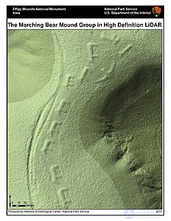
Lidar image of the “Marching Bears” mound, Effigy Mounds National Monument , USA
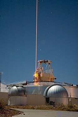
The Frequency-Added Sodium Optical Radar (FASOR), used at the Starfire Optical Range for lidar and laser guide star experiments, is tuned to the sodium D2a line and is used to excite sodium atoms in the upper atmosphere .
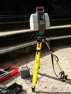
This lidar can be used to scan buildings, rock formations, and so on to create 3D models. Lidar can direct a laser beam across a wide range: its head rotates horizontally while a mirror tilts vertically. The laser beam is used to measure the distance to the first object in its path.
Lidar has terrestrial, airborne, and mobile applications. It is commonly used to create high-resolution maps, with applications in surveying , geomatics , archaeology , geography , geology , geomorphology , seismology , forestry , atmospheric physics, [ 6 ] laser guidance , airborne laser swath mapping (ALSM), and laser altimetry . It is used to create digital 3D representations of areas on the Earth's surface and the seafloor of the tidal and coastal zone by varying the wavelength of light. It is also increasingly used for control and navigation of autonomous vehicles and for the Ingenuity helicopter in its record-setting flights over the surface of Mars . [ 8 ] Since then, lidar has been widely used for atmospheric research and meteorology . Lidar instruments mounted on aircraft and satellites perform geodetic and cartographic surveys. A recent example is the experimental Advanced Airborne Research Lidar of the US Geological Survey. NASA has identified lidar as a key technology for enabling autonomous precision safe landing of future robotic and crewed lunar landers.
The development of quantum technologies has led to the emergence of quantum lidars, which demonstrate higher efficiency and sensitivity compared to traditional lidar systems.
The basic concept of lidar was developed by E. H. Synge in 1930, who proposed using powerful searchlights to probe the atmosphere.
Under the direction of Malcolm Stitch, Hughes Aircraft Company introduced the first lidar-like system in 1961, shortly after the invention of the laser. This system, designed for satellite tracking, combined laser image focusing with the ability to calculate distances by measuring the return time of the signal using appropriate sensors and data-acquisition electronics. It was originally called “Colidar” — an acronym for “coherent light Detecting and Ranging”, formed by analogy with the term “ radar ”, which is itself an acronym for “radio detection and ranging”. All laser rangefinders , laser altimeters , and lidar units are derived from the early “Colidar” systems.
The first practical ground application of the Colidar system was the “Colidar Mark II” — a large rifle-type laser rangefinder released in 1963, with a range of 11 km and an accuracy of 4.5 m, which was used for military targeting.The first mention of the word “lidar” as a separate word in 1963 suggests that it derived from the combination of “ light ” and “radar”: “Eventually the laser may become an extremely sensitive detector of certain wavelengths from distant objects. At the same time, it is being used to study the Moon by means of “lidar” (light radar)...” The name “ photonic radar ” is sometimes used to refer to a rangefinder operating in the visible spectrum, as lidar does.
The first applications of lidar were in meteorology, where the National Center for Atmospheric Research used it to measure clouds and pollution. The general public learned of the accuracy and usefulness of lidar systems in 1971 during the Apollo 15 mission, when astronauts used a laser altimeter to map the surface of the Moon. Although English no longer treats the word “radar” as an acronym (i.e., it is written in lower case), the word “lidar” has been capitalized as “LIDAR” in some publications since the 1980s. There is no consensus on capitalization. Various publications refer to lidar as “LIDAR”, . The US Geological Survey uses both “LIDAR” and “lidar”, sometimes in the same document; the New York Times mostly uses “lidar” for staff-written articles, although other news outlets, such as Reuters, may use lidar.
Lunar laser ranging experiments in the USSR began in 1963, and from 1973 systematic observations were conducted of all five corner reflectors located on the Moon by that time (“Lunokhod-1”, “Lunokhod-2”, “Apollo 11”, “Apollo 14”, “Apollo 15”)[17]:263,267,272. For laser ranging of artificial Earth satellites, the USSR launched satellites equipped with corner reflectors: “Intercosmos-17” (1977), “Intercosmos-Bulgaria-1300” (Soviet-Bulgarian, 1981), “Meteor-3” (1985), using the “Krym” laser rangefinder developed by Soviet scientists[18]:321,323.
In the USSR there were two families of lidar-based meteorological instruments intended for use at airfields (in both families, flashlamps were used as the source of the probing light flux):
Wavelengths vary depending on the target: from about 10 micrometers ( infrared ) to about 250 nanometers ( ultraviolet ). Typically light is reflected by means of backscattering , as opposed to pure reflection, which can be detected with a mirror. Different types of scattering are used for different lidar applications: most commonly Rayleigh scattering , Mie scattering , Raman scattering , and fluorescence . [ 6 ] Suitable combinations of wavelengths allow remote mapping of atmospheric content by revealing wavelength-dependent changes in the intensity of the returned signal. [ 27 ] The name “photonic radar” is sometimes used to refer to a rangefinder in the visible spectrum, such as lidar, although photonic radar more strictly refers to a radio-frequency rangefinder using photonic components.
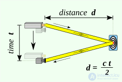
Lidar determines the distance to an object or surface using the formula :

where c — is the speed of light , d — is the distance between the detector and the object or surface being detected, and t — is the time required for the laser beam to travel to the object or surface being detected and then back to the detector.
There are two types of lidar detection schemes: “incoherent” or direct energy detection (which mainly measures changes in the amplitude of the reflected light) and coherent detection (best suited for measuring Doppler shifts, or changes in the phase of the reflected light). Coherent systems typically use optical heterodyne detection . [ 29 ] This is more sensitive than direct detection and allows them to operate at much lower power, but requires more complex transceivers.
Both types use pulsed models: either micro-pulse or high-energy . Micro-pulse systems use intermittent bursts of energy. They were developed as a result of the ever-increasing power of computers combined with advances in laser technology. They use significantly less laser energy, typically on the order of one microjoule , and are often “eye-safe”, meaning they can be used without precautions. High-power systems are widely used in atmospheric research, where they are used extensively to measure atmospheric parameters: cloud height, layering and density, cloud particle properties ( extinction coefficient , backscatter coefficient, depolarization ), temperature, pressure, wind, humidity, and trace gas concentrations (ozone, methane, nitrous oxide, etc.).

Unlike radio waves, which are effectively reflected only by sufficiently large metallic targets, light waves are subject to scattering in any medium, including air, so it is possible not only to determine the distance to opaque (light-reflecting) discrete targets, but also to record the intensity of light scattering in transparent media. The returning reflected signal passes through the same scattering medium as the beam from the source, undergoes secondary scattering, so recovering the actual parameters of a distributed optical medium — is a fairly complex task, solved by both analytical and heuristic methods.
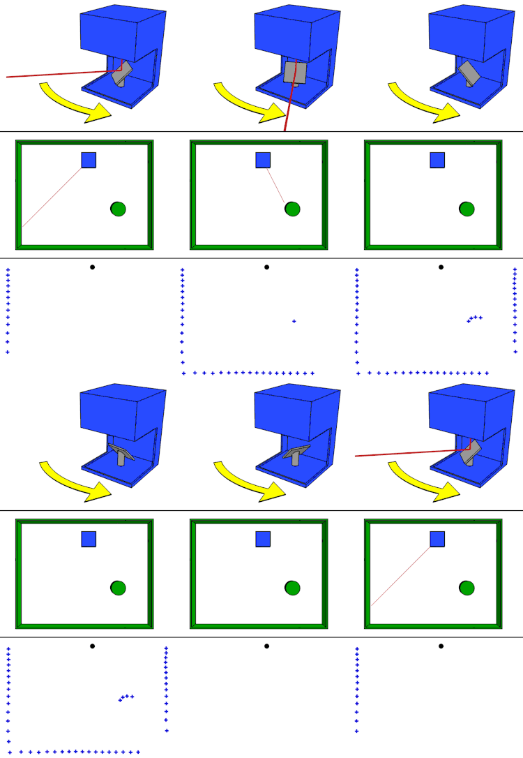
The simplest lidar system consists of a laser rangefinder reflected by a rotating mirror (top). The laser scans the scene being digitized in one or two dimensions (middle), collecting range data at set angular intervals (bottom).
The main differences in the design and operating principles of modern lidars lie in the beam-steering (scanning) modules. Scanning can be produced either by mechanical methods (using rotating mirrors or the motion of micro-electro-mechanical systems (MEMS)), or by means of a phased array[19].
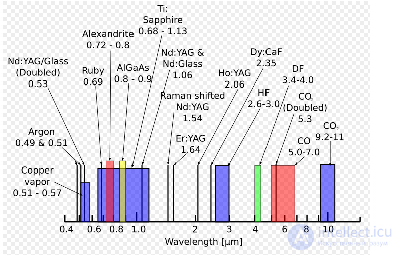
Wavelengths emitted by the most common lasers. Scale in micrometers
In the vast majority of designs, the emitter is a laser that produces short light pulses of high instantaneous power. The pulse repetition period, or modulation frequency, is chosen so that the pause between two consecutive pulses is no shorter than the response time from detectable targets (which may physically be farther away than the instrument's design range). The choice of wavelength depends on the laser's function and the instrument's safety and stealth requirements; the most commonly used are Nd:YAG lasers and the following wavelengths (in nanometers):
It is also possible to use (see Industrial and service robots) continuous amplitude modulation of the radiation by variable voltage instead of short pulses.
Most modern lidars use a cylindrical scan. This type of scan is the simplest to produce and the simplest to process further. However, it has drawbacks. For example, when using a cylindrical scan, there is a chance of missing narrow horizontal objects (such as a boom barrier). This problem is most often solved by using an additional lidar with a cylindrical scan, but oriented perpendicular to the first lidar.
In addition to the cylindrical scan, there are lidars with a “rosette” scan (“Rosette scanning pattern”). Producing this type of scan is more complex than producing a cylindrical scan, but lidars with a “rosette” scan do not experience the problems described above.
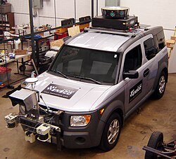
Two black cylinders mounted in front of the bumper — the scanning lidars of a self-driving car
The simplest atmospheric lidar systems have no aiming mechanism and are pointed vertically at the zenith.
Simple scanning heads are used to scan the horizon in one plane. In these, the stationary emitter and receiver are also pointed at the zenith; a mirror rotating around the emission axis is mounted at a 45° angle to the horizon and the emission line. In airborne installations, where a swath perpendicular to the direction of flight of the carrier aircraft must be scanned, the emission axis is horizontal. To synchronize the motor that rotates the mirror with the means of processing the received signal, precise rotor position sensors are used, as well as fixed reference marks applied to the transparent housing of the scanning head.
Scanning in two planes adds to this scheme a mechanism that turns the mirror through a fixed angle with each rotation of the head — this is how a cylindrical scan of the surrounding world is formed. Given sufficient computing power, it is possible to use a rigidly fixed mirror and a bundle of diverging beams — in such a design, one “frame” is formed in a single rotation of the head.
Scanning can also be performed using micro-electro-mechanical systems. Such systems make it possible to significantly reduce the dimensions and increase the reliability of the products.
Lasers with a wavelength of 600–1000 nm are most commonly used for non-scientific purposes. The maximum laser power is limited, or an automatic shutdown system is used that turns off the laser at a certain altitude to ensure the eye safety of people on the ground.
One common alternative, lasers with a wavelength of 1550 nm, are eye-safe at relatively high power, since this wavelength is strongly absorbed by water and barely reaches the retina, although camera sensors can still be damaged. However, the trade-off is that current detector technology is less advanced, so these wavelengths are typically used at longer ranges with lower precision. They are also used for military purposes, since the 1550 nm wavelength is not visible in night-vision goggles , unlike the shorter 1000 nm infrared laser.
Airborne lidars for topographic mapping typically use diode-pumped YAG lasers with a wavelength of 1064 nm , while bathymetric systems (depth surveys) typically use diode-pumped, frequency-doubled YAG lasers with a wavelength of 532 nm, since 532 nm radiation penetrates water with much less attenuation than 1064 nm radiation. Laser settings include the pulse repetition rate (which determines the data acquisition speed). Pulse duration is typically determined by the length of the laser cavity, the number of passes required for the gain medium (YAG, YLF, etc.), and the Q-switching (pulse) rate. The best target resolution is achieved with shorter pulses, provided that the lidar's detectors and electronics have sufficient bandwidth.
A phased array can illuminate any direction using a microscopic array of individual antennas. Controlling the timing (phase) of each antenna directs the combined signal in a particular direction. Phased arrays have been used in radars since the 1940s. On the order of a million optical antennas are used to produce a radiation pattern of a given size in a given direction. To achieve this, the phase of each individual antenna (emitter) is precisely controlled. Using the same technology in lidar is extremely difficult, if possible at all. The main problems are that all the individual emitters must be coherent (technically, derived from the same “master” oscillator or laser source), must have dimensions close to the wavelength of the emitted light (a range of 1 µm) in order to act as a point source, and their phases must be controlled with high precision.
Micro-electro-mechanical mirrors (MEMS) are not fully solid-state. However, their miniature form factor provides many of the same cost advantages. A single laser is aimed at a single mirror, which can be reoriented to view any part of the target field. The mirror rotates at high speed. However, MEMS systems typically operate in one plane (left to right). Adding a second dimension usually requires a second mirror that moves up and down. Alternatively, another laser can hit the same mirror at a different angle. MEMS systems can be damaged by shocks/vibrations and may require recalibration.
Imaging speed depends on the scan rate. Two oscillating flat mirrors, a combination with a polygon mirror, and a two-axis scanner are used to scan azimuth and elevation angle . The choice of optics affects angular resolution and detection range. A mirror with an aperture or a beam splitter can be used to collect the reflected signal.
Two main photodetector technologies are used in lidars: solid-state photodetectors, such as silicon avalanche photodiodes , or photomultipliers . Receiver sensitivity is another parameter that must be balanced when designing a lidar.
Lidar sensors mounted on mobile platforms, such as aircraft or satellites, require the use of measuring instruments to determine the sensor's absolute position and orientation. Such devices typically include a global positioning system (GPS) receiver and an inertial measurement unit (IMU).
An active phased array antenna forms a laser beam using multiple transmitting modules, each generating radiation with its own parameters. This allows the beam direction to be controlled. The use of phased arrays (PAR) in lidars makes it possible to eliminate moving parts and thus extend the product's service life.
The dynamic range of the receiving path plays an important role. For example, the receiving path of the latest (as of 2006) MuCAR-3 machine-vision subsystem, with a dynamic range of 1:106, provides an effective operating radius of 2 to 120 m (a factor of only 1:60). To avoid overloading the receiver with intense illumination from “near-zone” scattering, long-range systems employ high-speed mechanical shutters that physically block the receiving optical channel. In short-range devices with a response time of under a microsecond, this option is not available.
Lidar uses active sensors, which provide their own source of illumination. Energy from the source strikes objects, and the reflected energy is detected and measured by sensors. The distance to the object is determined by recording the time between the transmitted and reflected pulses and using the speed of light to calculate the distance traveled. [ 33 ] Flash lidar makes it possible to obtain three-dimensional images thanks to the camera's ability to emit a more powerful flash and determine the spatial relationships and dimensions of the area of interest using the reflected energy. This provides a more accurate image, since the resulting frames do not need to be stitched together, and the system is insensitive to platform motion. This results in less distortion. [ 34 ]
3D imaging can be carried out using either scanning or non-scanning systems. “Gated-viewing 3D laser radar” is a non-scanning laser rangefinding system that uses a pulsed laser and a fast gated-view camera. Research has begun into virtual beam steering using digital light processing (DLP) technology.
Lidar for imaging can also be implemented using arrays of high-speed detectors and arrays of modulation-sensitive detectors, typically built on individual chips using complementary metal-oxide-semiconductor (CMOS) and hybrid CMOS/ charge-coupled device (CCD) fabrication technologies. In these devices, each pixel performs some local processing, such as demodulation or high-speed gating, downconverting the signals to video frequency, so that the array can be read out like a camera. Using this technology, many thousands of pixels/channels can be captured simultaneously. [ 35 ] High-resolution 3D lidar cameras use homodyne detection with electronic CCD or CMOS shuttering . [ 36 ]
Coherent imaging lidar uses synthetic-aperture heterodyne detection , to allow a single-element directional receiver to act as though it were an imaging array. [ 37 ]
In 2014, Lincoln Laboratory announced a new imaging chip with more than 16,384 pixels, each capable of detecting a single photon, allowing it to capture a large area in a single image. An earlier generation of the technology with a quarter as many pixels was sent by the US military after the earthquake in Haiti in January 2010. A single pass of a business jet at an altitude of 3000 m (10,000 feet) over Port-au-Prince made it possible to take instant snapshots of 600 m2 (2000 feet) squares of the city at a resolution of 30 cm (1 foot), showing the exact height of rubble scattered across city streets. [ 38 ] The new system is ten times better and can produce much larger maps much faster. The chip uses indium gallium arsenide (InGaAs), which operates in the infrared spectrum at a relatively long wavelength, providing higher power and greater range. In many applications, such as self-driving cars, the new system will reduce costs, since it does not require a mechanical component to aim the chip. InGaAs uses less hazardous wavelengths than traditional silicon detectors operating in the visible spectrum. [ 39 ] New technologies for infrared single-photon-counting lidar are developing rapidly, including arrays and cameras on various semiconductor and superconducting platforms. [ 40 ]
Lidar can be oriented in nadir , zenith , or horizontally. For example, lidar altimeters look down, atmospheric lidars — up, and collision-avoidance lidar systems — sideways.
Laser projections of lidars can be manipulated using various methods and mechanisms to create a scanning effect: the standard spindle type, which rotates to provide a 360-degree view; solid-state lidar, which has a fixed field of view but no moving parts and can use either MEMS or optical phased arrays to steer the beams; and flash lidar, which spreads a flash of light over a large field of view before the signal is reflected back to the detector. [ 41 ]
Lidar applications can be divided into airborne and terrestrial. [ 42 ] Both types require scanners with different characteristics depending on the purpose of data collection, the size of the area to be covered, the desired measurement range, equipment cost, etc. Space-based platforms are also possible; see satellite laser altimetry .
Airborne lidar (also airborne laser scanning ) — is when a laser scanner, mounted on an aircraft in flight, creates a three-dimensional point cloud model of the landscape. This is currently the most detailed and accurate method of creating digital elevation models , replacing photogrammetry . One of the main advantages over photogrammetry is the ability to filter out reflections from vegetation from the point cloud model to create a digital terrain model , representing ground surfaces such as rivers, trails, cultural heritage sites, etc., that are hidden by trees. Within the category of airborne lidar, a distinction is sometimes made between high-altitude and low-altitude applications, but the main difference lies in the reduction of both the accuracy and density of data points obtained at higher altitudes. Airborne lidar can also be used to create bathymetric models in shallow water. [ 43 ]
The main components of airborne lidar are digital terrain models (DTMs) and digital surface models (DSMs). Points on the ground surface are represented as vectors of discrete points, while DTMs and DSMs are interpolated raster grids of discrete points. The process also involves acquiring digital aerial photographs. Airborne lidar is used to interpret deep-seated landslides, for example beneath vegetation cover, scarps, tension cracks, or fallen trees. Airborne lidar digital terrain models allow one to see through the forest canopy and perform detailed measurements of scarps, erosion, and the tilt of power-line supports. [ 44 ]
Airborne lidar data is processed using a toolset called the Toolbox for Lidar Data Filtering and Forest Studies (TIFFS) [ 45 ] to filter lidar data and study terrain. The data is interpolated into digital terrain models using software. The laser is aimed at the area to be mapped, and the height of each point above the ground is calculated by subtracting the original z-coordinate from the corresponding digital terrain model elevation. Based on this height above ground, vegetation-free data is obtained, which may include objects such as buildings, power lines, flying birds, insects, etc. The remaining points are treated as vegetation and used for modeling and mapping. For each of these plots, lidar metrics are calculated by computing statistics such as mean, standard deviation, skewness, percentiles, root mean square, etc. [ 45 ]
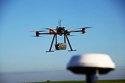
Lidar scanning by an unmanned aerial vehicle (UAV)
There are currently many commercial lidar systems for unmanned aerial vehicles on the market. These platforms can systematically scan large areas or serve as a cheaper alternative to manned aircraft for scanning smaller volumes. [ 46 ]
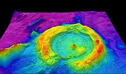
Airborne bathymetric lidar technology — a high-resolution multibeam lidar map showing impressive faults and deformations of the seafloor, in shaded relief and colored by depth.
The airborne bathymetric lidar system involves measuring the travel time of the signal from the source to its return to the sensor. The data collection method includes a seafloor mapping component and a ground control component, including video transects and sampling. The system operates using a green-spectrum laser beam (532 nm). [ 47 ] Two beams are projected onto a rapidly rotating mirror, which creates an array of points. One of the beams penetrates the water and, under favorable conditions, also detects the seabed surface.
Water depth measured by lidar depends on water clarity and absorption at the wavelength used. Water is most transparent to green and blue light, so they penetrate deepest into clear water. [ 48 ] Blue-green light at 532 nm, produced by the output of a frequency-doubled solid-state IR laser, is the standard for airborne bathymetry. This light can penetrate water, but the pulse strength decays exponentially with the distance traveled in water. [ 47 ] Lidar can measure depth from about 0.9 to 40 m (3 to 131 feet) with a vertical accuracy on the order of 15 cm (6 inches). Surface reflection makes it difficult to resolve water at depths of less than 0.9 m (3 feet), and absorption limits the maximum depth. Turbidity causes scattering and plays an important role in determining the maximum depth that can be resolved in most situations, and dissolved pigments can increase absorption depending on wavelength. [ 48 ] Other reports indicate that the water penetration depth is typically two to three Secchi depths. Bathymetric lidar is most useful in the 0–10 m (0–33 feet) depth range for coastal mapping. [ 47 ]
On average, in reasonably clear coastal seawater, lidar can penetrate to a depth of about 7 m (23 feet), and in turbid water — up to 3 m (10 feet). The average value found by Saputra et al. (2021) is, for the green laser beam, a depth approximately one-and-a-half to two times the Secchi depth in Indonesian waters. Water temperature and salinity affect the refractive index, which in turn has little effect on the depth calculation. [ 49 ]
The resulting data shows the full extent of the land surface protruding above the seafloor. This method is extremely useful, since it will play an important role in a large-scale seafloor mapping program. Mapping provides data on both land relief and underwater elevations. Visualization of seafloor reflections is another product of this system, which can be useful for mapping underwater habitats. This method was used for three-dimensional mapping of California's waters using hydrographic lidar. [ 50 ]
Airborne lidar systems traditionally could only capture a few peak returns, while more modern systems capture and digitize the entire reflected signal. [ 51 ] Scientists analyzed the waveform signal to extract peak returns using Gaussian decomposition . [ 52 ] Zhuang et al., 2017 used this approach to estimate above-ground biomass. [ 53 ] Processing huge volumes of full-waveform data is difficult. Therefore, Gaussian decomposition of waveforms is efficient, since it reduces the data and is supported by existing workflows that support the interpretation of three-dimensional point clouds . Recent studies have explored voxelization . Waveform sample intensities are inserted into a voxelized space (a three-dimensional grayscale image ), creating a three-dimensional representation of the scanned area. [ 51 ] Relevant metrics and information can then be extracted from this voxelized space. Structural information can be extracted using three-dimensional metrics from local areas, and there is a study in which the voxelization method was used to detect dead eucalyptus trees in Australia. [ 54 ]
Terrestrial applications of lidar (also terrestrial laser scanning ) occur at the Earth's surface and can be either stationary or mobile. Stationary terrestrial scanning is most commonly used as a surveying method, for example in traditional topography, monitoring, cultural heritage documentation, and forensics. [ 42 ] Three-dimensional point clouds obtained with these types of scanners can be matched with digital images of the scanned area taken from the scanner's location, to create realistic three-dimensional models in a relatively short time compared to other technologies. Each point in the point cloud is assigned a pixel color from the image taken at the same location and direction as the laser beam that created the point.
Mapping terrestrial objects with lidar involves the process of creating an occupancy grid map. This process involves an array of cells divided into a grid, which uses a mechanism for storing elevation values when lidar data hits the corresponding grid cell. A binary map is then created by applying a specific threshold value to the cell values for further processing. The next step is processing the radial distance and z-coordinates of each scan to determine the three-dimensional points corresponding to each of the specified grid cells, resulting in the data-formation process. [ 55 ]
Mobile lidar (also mobile laser scanning ) — is when two or more scanners are attached to a moving vehicle to collect data along a route. These scanners almost always work in pairs with other equipment, including GNSS receivers and inertial measurement units . One example of application is street surveying, where power lines, precise bridge heights, adjacent trees, etc. must be accounted for. Instead of collecting each of these measurements individually in the field with a total station , a three-dimensional model can be created from the point cloud, in which all the necessary measurements can be made depending on the quality of the collected data. This eliminates the problem of forgetting to take a measurement, provided the model is available, reliable, and has an appropriate level of accuracy.
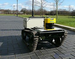
This mobile robot uses lidar for mapping and obstacle avoidance.
In addition to those listed below, there is a wide range of lidar applications, as is often mentioned in national lidar dataset programs. These applications are largely determined by the effective detection range of objects; the resolution, which determines the accuracy of object identification and classification by lidar; and reflection distortion, which refers to how well lidar can distinguish objects in the presence of bright objects, such as reflective signs or bright sunlight. [ 41 ]
Companies are working to reduce the cost of lidar sensors, which currently ranges from $1,200 to more than $12,000. Lower prices will make lidar more attractive for new markets. [ 56 ]
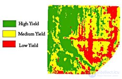
Lidar is used to analyze crop yields in agricultural fields.
Agricultural robots are used for various purposes: from spraying seeds and fertilizers to sensor technologies, as well as for crop inspection for weed control .
Lidar can help determine where expensive fertilizers should be applied. It can create a topographic map of fields and show the slopes and illumination of farmland. Researchers at the Agricultural Research Service used this topographic data together with farmland yield data from previous years to classify land into high-, medium-, or low-yield zones. [ 57 ] This indicates where fertilizer should be applied to maximize yield.
Lidar is now used to monitor insects in the field. Lidar makes it possible to track the movement and behavior of individual flying insects, determining their sex and species. [ 58 ] In 2017, a patent application for this technology was published in the US, Europe, and China. [ 59 ]
Another application is mapping crops in orchards and vineyards to track foliage growth and the need for pruning or other care, detecting changes in fruit yield, or counting plants.
Lidar is useful in conditions with no GNSS signal, such as in nut and fruit orchards, where foliage interferes with agricultural machinery that would otherwise use precise GNSS positioning. Lidar sensors can detect and track the relative position of rows, plants, and other markers, allowing agricultural machinery to keep working until the GNSS signal is restored.
Weed control requires identifying plant species. This can be achieved using three-dimensional lidar and machine learning . [ 60 ] Lidar creates outlines of plants as a “point cloud” with range and reflectance values. This data is transformed, and features are extracted from it. If the species is known, the features are added as new data. The species is labeled, and its characteristics are initially stored as an example for identifying the species in a real environment. This method is effective because it uses low-resolution lidar and supervised learning. It involves a computationally simple set of features with general statistical characteristics that do not depend on the size of the plant. [ 60 ]
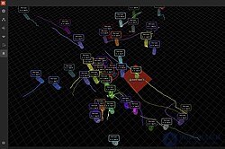
A LiDAR-based spatial intelligence system tracks individual passengers in real time at passport control.
In April 2025, Dallas/Fort Worth International Airport announced the deployment of a LiDAR-based platform for real-time monitoring of passenger and vehicle flows. [ 61 ]
Lidar has many applications in archaeology, including planning fieldwork, mapping sites beneath forest canopy, and surveying extensive, continuous features indistinguishable from the ground surface. [ 62 ] Lidar makes it possible to quickly and inexpensively create high-resolution datasets. Products derived from lidar can easily be integrated into a geographic information system (GIS) for analysis and interpretation.
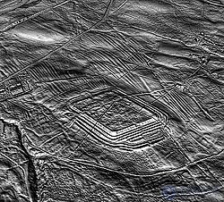
Lidar image of the Roman fort of Epiacum in Northumberland, England.
Lidar can also help create high-resolution digital elevation models (DEMs) of archaeological sites, which can reveal microrelief that is otherwise hidden by vegetation. The intensity of the returned lidar signal can be used to detect objects hidden beneath flat vegetated surfaces, such as fields, especially when mapping using the infrared spectrum. The presence of such objects affects plant growth and, consequently, the amount of infrared light reflected back. For example, at Fort Beauséjour - Fort Cumberland National Historic Site, Canada, lidar detected archaeological features associated with the siege of the fort in 1755. Features that could not be distinguished on the ground or by aerial photography were identified by overlaying hillshades of DEMs created using artificial illumination from different angles. Another example is the work at Caracol by Arlen Chase and his wife Diane Zaino Chase . In 2012, lidar was used to search for the legendary city of Ciudad Blanca, or the “City of the Monkey God,” in the La Mosquitia region of the Honduran jungle. Over a seven-day mapping period, evidence of man-made structures was discovered. In June 2013, the rediscovery of the city of Mahendraparvata was announced. In southern New England, lidar has been used to detect stone walls, building foundations, abandoned roads, and other landscape features hidden in aerial photographs by the region's dense forest canopy. In Cambodia, lidar data was used by Damian Evans and Roland Fletcher to reveal anthropogenic changes to the landscape of Angkor
In 2012, lidar revealed that the Purépecha settlement of Angamuco in Michoacán , Mexico, had about as many buildings as modern-day Manhattan; and in 2016, its use to map ancient Maya roads in northern Guatemala revealed 17 elevated roadways connecting the ancient city of El Mirador with other sites. In 2018, archaeologists using lidar discovered more than 60,000 man-made structures in the Maya Biosphere Reserve , a “major breakthrough” that showed the Maya civilization was much larger than previously believed. In 2024, archaeologists using lidar discovered monuments in the Upano Valley .
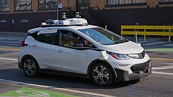
A Cruise Automation self-driving car with five Velodyne lidars on the roof
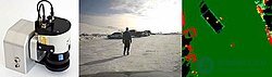
Projected 3-D laser system using a SICK LMC lidar sensor
Autonomous vehicles can use lidar to detect and avoid obstacles for safe navigation in the environment. The adoption of lidar was a key development that was a key factor for Stanley , the first autonomous vehicle to successfully complete the DARPA Grand Challenge . [ 89 ] Point cloud output from the lidar sensor provides the data needed by the robot's software to determine potential obstacles in the environment and the robot's location relative to those potential obstacles. The Singapore-MIT Alliance for Research and Technology (SMART) in Singapore is actively developing lidar-based technologies for autonomous vehicles. [ 90 ]
The very first generations of automotive adaptive cruise control systems used only lidar sensors.
In transportation systems, ensuring the safety of vehicles and passengers, as well as developing electronic driver assistance systems, requires a critical understanding of the state of the vehicle and its surrounding environment. Lidar systems play an important role in ensuring the safety of transportation systems. Many electronic systems that improve safety and assist the driver, such as adaptive cruise control (ACC), emergency brake assist, and the anti-lock braking system (ABS), depend on sensing the environment around the vehicle for their autonomous or semi-autonomous operation. This is achieved through lidar mapping and evaluation.
Modern lidar systems use rotating hexagonal mirrors that split the laser beam. The top three beams are used to detect vehicles and obstacles ahead, while the lower beams are used to detect lane markings and road features. [ 91 ] The main advantage of using lidar is that a spatial structure is obtained, and this data can be combined with other sensors, such as radar, etc., to obtain a better picture of the vehicle's environment in terms of the static and dynamic properties of objects present in the environment. On the other hand, a significant problem with lidar is the difficulty of reconstructing point cloud data in poor weather conditions. For example, during heavy rain, light pulses emitted by the lidar system are partially reflected by raindrops, which adds noise to the data called “echo.”
Obstacle detection and road scene recognition using lidar, proposed by Kun Zhou et al. [ 93 ], not only focuses on detecting and tracking objects, but also recognizes lane markings and road features. As mentioned earlier, lidar systems use rotating hexagonal mirrors that split the laser beam into six beams. The top three layers are used to detect moving objects ahead, such as vehicles and roadside objects. The sensor is made of a weather-resistant material. Data detected by the lidar is clustered into several segments and tracked using a Kalman filter . Data clustering here is performed based on the characteristics of each segment, based on an object model that distinguishes between different objects, such as vehicles, signs, etc. These characteristics include object dimensions, etc. Reflectors on the rear edges of vehicles are used to differentiate vehicles from other objects. Object tracking is performed using a two-stage Kalman filter that accounts for tracking stability and accelerated object motion [ 91 ]. Lidar reflection intensity data is also used to detect curbs using robust regression to eliminate occlusion. Road markings are detected using a modified Otsu method that distinguishes between rough and glossy surfaces. [ 94 ]
Roadside reflectors marking the edge of the traffic lane are sometimes hidden for various reasons. Other information is therefore needed to recognize the road boundary. The lidar used in this method can measure the reflectivity of an object. In this way, this data can be used to recognize the road boundary. In addition, using a sensor with a head that is resistant to weather conditions helps detect objects even in poor weather. A canopy height model before and after a flood is a good example. Lidar can obtain highly detailed data on canopy height as well as on the road boundary. Lidar measurements help determine the spatial structure of an obstacle. This helps distinguish objects by size and assess the consequences of driving through it. [ 95 ] Lidar systems provide a longer range and a wider field of view, which helps detect obstacles around curves. This is one of the main advantages compared with radar systems, which have a narrower field of view. Combining lidar measurements with various sensors makes the system reliable and useful in real-time applications, since lidar-dependent systems cannot assess dynamic information about a detected object. [ 95 ] Lidar has been shown to be capable of being manipulated, for instance by causing self-driving cars to make evasive maneuvers. [ 96 ]
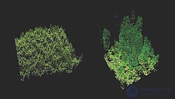
A lidar image comparing an old forest (right) with a newly planted stand (left)
Lidar has also found numerous applications for mapping natural and managed landscapes, such as forests, wetlands [ 97 ] and grasslands. Canopy height, biomass measurements and leaf area can be studied using airborne lidar systems. Similarly, lidar is also used in many industries, including energy and rail, as well as by departments of transportation as a faster surveying method. Topographic maps can also be easily obtained using lidar, including for recreational use, such as in creating orienteering maps. [ 102 ] Lidar has also been applied to assess and analyze the biodiversity of plants, fungi and animals. Using southern bull kelp in New Zealand, coastal lidar mapping data were compared with population genome data to form hypotheses about the occurrence and timing of prehistoric earthquakes. [ 106 ]
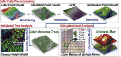
A typical workflow for obtaining forest information at the individual-tree or plot level from lidar point clouds [ 107 ]
Lidar systems are also applied to improve forest management. [ 108 ] Measurements are used to inventory forest plots, as well as to calculate the height, crown width and diameter of individual trees. In other types of statistical analysis, lidar data are used to estimate general plot information, such as canopy volume, mean, minimum and maximum height, vegetation cover, biomass and carbon density. [ 107 ] Airborne lidar was used to map wildfires in Australia in early 2020. The data were processed to view bare earth and determine healthy and burned vegetation.
High-resolution digital elevation maps produced by airborne and terrestrial lidar have led to significant advances in geomorphology (the branch of earth science that studies the origin and evolution of the Earth's surface topography). Lidar's ability to detect subtle topographic features, such as river terraces and riverbanks, [ 110 ] glacial landforms, [ 111 ] to measure the height of the ground surface beneath vegetation canopy, to better resolve spatial derivatives of elevation, to detect rockfalls, and to detect elevation changes between repeat surveys [ 114 ] has enabled many new studies of the physical and chemical processes shaping landscapes. In 2005, the Tour Ronde in the Mont Blanc massif became the first high-mountain peak on which lidar was used to monitor an increasing frequency of severe rockfalls on large rock faces, thought to be caused by climate change and high-altitude permafrost degradation. [ 116 ]
Lidar is also used in structural geology and geophysics as a combination of airborne lidar and GNSS for detecting and studying faults, and for measuring uplift. [ 117 ] The output of the two technologies can produce extremely accurate terrain models for an area — models that can even measure the elevation of the ground through trees. This combination is best known for having been used to find the location of the Seattle Fault in Washington, USA. [ 118 ] This combination has also measured the uplift at Mount St. Helens, using data from before and after the 2004 uplift. [ 119 ] Airborne lidar systems monitor glaciers and are able to detect even barely noticeable amounts of growth or shrinkage. NASA's ICESat satellite system includes a lidar subsystem for this purpose. NASA's Airborne Topographic Mapper [ 120 ] is also widely used for monitoring glaciers and for conducting analyses of changes in the coastal zone. This combination is also used by soil scientists in creating soil surveys. Detailed terrain modeling allows soil scientists to observe changes in slope and breaks in terrain that indicate patterns of spatial relationships between soils.
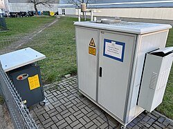
A short-range lidar at the Institute of Geophysics, Warsaw, Poland
Initially based on ruby lasers, lidar for meteorological applications was developed soon after the invention of the laser and represents one of the earliest applications of laser technology. Since then, the capabilities of lidar technology have expanded significantly, and lidar systems are used to perform a number of measurements, including cloud profiling, wind measurement, aerosol studies, and the quantification of various atmospheric constituents. Atmospheric constituents can, in turn, provide useful information, including surface pressure (by measuring oxygen or nitrogen absorption), greenhouse gas emissions (carbon dioxide and methane), photosynthesis (carbon dioxide), fires (carbon monoxide), and humidity (water vapor). Atmospheric lidars can be ground-based, airborne, or satellite-based, depending on the type of measurement.
Remote sensing of the atmosphere using lidar works in two ways:
Backscatter from the atmosphere directly yields an estimate of clouds and aerosols. Other measurements derived from backscatter, such as wind or cirrus ice crystals, require careful selection of wavelength and/or the polarization being detected. Doppler lidar and Doppler Rayleigh lidar are used to measure temperature and wind speed along the beam by measuring the frequency of the scattered light. The Doppler broadening of moving gases allows properties to be determined from the resulting frequency shift. [ 121 ] Scanning lidars, such as NASA's Holographic Airborne Rotating Lidar Instrument Experiment (HARLIE) conical scanning lidar, have been used to measure atmospheric wind speed. [ 122 ] ESA's ADM-Aeolus wind mission will carry a Doppler lidar system to provide global measurements of vertical wind profiles. [ 123 ] A Doppler lidar system was used at the 2008 Summer Olympics to measure wind fields during sailing competitions. [ 124 ]
Doppler lidar systems are also beginning to be successfully applied in the renewable energy sector to obtain data on wind speed, turbulence, veer and wind shear. Both pulsed and continuous-wave systems are used. Pulsed systems use signal timing to obtain vertical resolution, whereas continuous-wave systems use detector focusing.
The term “aeolics” has been proposed to describe the joint and interdisciplinary study of wind using computational fluid dynamics modeling and Doppler lidar measurements. [ 125 ]
Reflectance from the ground obtained by airborne lidar gives a measure of surface reflectivity (provided that atmospheric transmittance is well known) at the lidar wavelength; however, ground reflectance is usually used for making atmospheric absorption measurements. “Differential absorption lidar” (DIAL) measurements use two or more closely spaced (less than 1 nm apart) wavelengths to cancel out surface reflectivity as well as other transmission losses, since these factors are relatively insensitive to wavelength. When tuned to the appropriate absorption lines of a particular gas, DIAL measurements can be used to determine the concentration (mixing ratio) of that particular gas in the atmosphere. This is called the integrated path differential absorption (IPDA) approach, since it is a measure of the integrated absorption along the entire lidar path. IPDA lidars can be either pulsed or continuous-wave [ 128 ] and typically use two or more wavelengths. [ 129 ] IPDA lidars have been used for the remote sensing of carbon dioxide and methane. [ 130 ]
Synthetic array lidar allows imaging without the use of a detector. It can be used for Doppler velocimetry, ultrafast imaging (millions of frames per second), and for suppressing the speckle effect in coherent lidar. [ 37 ] An extensive bibliography on lidar for atmospheric and hydrospheric applications is provided by Grant. [ 131 ]
In Japan, differential absorption lidar (DIAL) and Raman lidar technologies are being developed to improve the accuracy of flood and precipitation forecasting in response to increasingly frequent and severe weather events caused by climate change.
As part of the Cabinet Office's BRIDGE (Bridging the gap between R&D and Society 5.0) program, a multi-institutional research consortium led by Kyushu University, including EKO Instruments Co. Ltd., Kyoto University, and several national universities and institutes, was selected by the Kyushu Regional Development Bureau of the Ministry of Land, Infrastructure, Transport and Tourism (MLIT) to conduct advanced research in meteorological sensing and flood risk modeling.
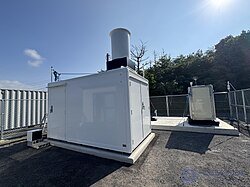
An EKO Instruments lidar and DIAL installation on Fukue Island, Nagasaki, Japan.
The project focuses on:
In May 2025, EKO Instruments began a field study on Goto-Fukue Island in Nagasaki Prefecture, using a Micropulse DIAL lidar system provided by the National Center for Atmospheric Research (NSF NCAR). The study compares the performance of DIAL with existing Raman lidar systems.
In addition, in February 2025, EKO Instruments Co. Ltd. signed a technology licensing agreement with Montana State University, NSF NCAR and NASA, covering key patents related to DIAL. The company is working on commercializing a compact and efficient lidar system by 2026. EKO Technology License
Although through June 2025 most of the work will be focused on flood-prone regions of Japan such as Kyushu, EKO Instruments Co. Ltd. has stated its intention to contribute to improving global flood resilience, targeting other vulnerable regions, including the United States and Europe, where extreme weather events and flooding are becoming more frequent. The goal is to expand the application of advanced atmospheric lidar and AI-based forecasting systems to support international disaster preparedness and mitigation efforts.
The initiative has received national attention, having been covered by NHK Fukuoka NHK and the Nikkan Kogyo Shimbun, and is expected to play a key role in the development of next-generation weather forecasting infrastructure.
Lidar speed guns are used by police to measure vehicle speeds for the purpose of enforcing speed limits. In addition, they are used in forensics to help investigate crime scenes. Scene scanning is performed to precisely determine the location of objects, the presence of blood, and other important information for subsequent analysis. Scanning can also be used to determine bullet trajectories in shooting cases.
Few cases of the military use of lidar are known, as they are classified (for example, measuring the speed of the stealthy nuclear-capable AGM-129 ACM cruise missile using lidar), but significant research is currently underway on its use for imaging. Higher-resolution systems gather enough detail to identify targets, such as tanks. An example of a military application of
продолжение следует...
Часть 1 Lidar (Light Detection and Ranging)
Часть 2 Variants - Lidar (Light Detection and Ranging)

Comments