
Lecture
Это окончание невероятной информации про лидар.
...
lidar is Areté Associates' Airborne Laser Mine Detection System (ALMDS) for mine countermeasures. [ 132 ]
A NATO report (RTO-TR-SET-098) assessed potential remote-detection technologies for discriminating biological warfare agents. The potential technologies evaluated were: long-wavelength infrared (LWIR), differential scattering (DISC), and ultraviolet-laser-induced fluorescence (UV-LIF). The report concluded that: based on the results of tests and discussions of lidar systems, the task group recommends that the best option for short-term (2008–2010) application of remote-detection systems was UV-LIF, [ 133 ] although in the longer term, other methods, such as remote-detection Raman spectroscopy, may prove useful for identifying biological warfare agents.
A compact, short-range spectrometric lidar operating on the basis of laser-induced fluorescence (LIF) will detect the presence of aerosolized biological threats at critical facilities in enclosed, semi-enclosed, and open spaces such as stadiums, subways, and airports. This near-real-time capability will enable rapid detection of a bioaerosol release and timely measures to protect people and minimize the extent of contamination. [ 134 ]
The Long-Range Biological Standoff Detection System (LR-BSDS) was developed for the US Army to provide the earliest possible warning of a biological attack. It is a helicopter-mounted airborne system for detecting clouds of synthetic aerosols containing biological and chemical agents at long range. The LR-BSDS, with a detection range of 30 km or more, was fielded in June 1997. [ 135 ] Five lidars manufactured by the German company Sick AG were used for short-range detection on Stanley, the driverless car that won the 2005 DARPA Grand Challenge.
A robotic Boeing AH-6 performed a fully autonomous flight in June 2010, including avoiding obstacles using lidar.
Ore volume calculations are performed by periodic (monthly) scanning of ore extraction zones, followed by comparison of the surface data with the previous scan. [ 138 ]
Lidar sensors can also be used to detect and avoid obstacles by robotic mining machinery, such as Komatsu's Autonomous Haulage System (AHS) [ 139 ], used at Rio Tinto's mine of the future.
A worldwide network of observatories uses lidars to measure the distance to reflectors placed on the Moon, allowing the Moon's position to be measured to millimeter precision and enabling tests of general relativity. MOLA, the Mars Orbiter Laser Altimeter, used a lidar instrument on an orbiting satellite of Mars (NASA's Mars Global Surveyor) to conduct an extremely accurate global topographic survey of the red planet. Laser altimeters have created global terrain models of Mars, the Moon (Lunar Orbiter Laser Altimeter (LOLA)), and Mercury (Mercury Laser Altimeter (MLA), NEAR–Shoemaker Laser Rangefinder (NLR)).
Future missions will also include experiments with laser altimeters, such as the Ganymede Laser Altimeter (GALA) as part of the Jupiter Icy Moons Explorer (JUICE) mission. [ 140 ]
In September 2008, NASA's Phoenix lander used lidar to detect snow in the Martian atmosphere.
In atmospheric physics, lidar is used as a remote-sensing instrument to measure the density of certain constituents of the middle and upper atmosphere, such as potassium, sodium, molecular nitrogen and oxygen. These measurements can be used to calculate temperature. Lidar can also be used to measure wind speed and to obtain information on the vertical distribution of aerosol particles. [ 142 ]
At the JET nuclear fusion research facility in the United Kingdom, near Abingdon, Oxfordshire, lidar Thomson scattering is used to determine electron density and plasma temperature profiles. [ 143 ]
Lidar is widely used in rock mechanics to characterize rock masses and detect slope changes. Some important geomechanical properties of rock can be obtained from three-dimensional point clouds acquired by lidar. Some of these properties are:
Some of these properties have been used to assess the geomechanical quality of a rock mass using the RMR index. Moreover, since discontinuity orientation can be obtained using existing methodologies, the geomechanical quality of a rock slope can be assessed using the SMR index. [ 150 ] In addition, comparing different three-dimensional point clouds of a slope acquired at different times allows researchers to study the changes that have occurred at the site over that time interval as a result of rockfalls or other landslide processes.
THOR is a laser designed to measure the Earth's atmospheric conditions. The laser penetrates the cloud cover and measures the thickness of the halo of reflected radiation. The sensor has a fiber-optic aperture 7+1⁄2 inches (19 cm) wide, which is used to measure the return light.
Lidar technology is used in robotics for environmental perception, as well as for object classification. The ability of lidar technology to provide three-dimensional terrain maps, highly accurate determination of distance to the ground, and closing speed can enable the safe landing of robotic and crewed vehicles with a high degree of precision. Lidar is also widely used in robotics for simultaneous localization and mapping and is well integrated into robot simulators. See the “Military” section above for additional examples.
Lidar is increasingly used to determine range and to calculate the orbital element of relative velocity during spacecraft rendezvous and station-keeping operations. Lidar has also been used for atmospheric research from space. Short pulses of laser light emitted by a spacecraft can reflect off the tiniest particles in the atmosphere and return to a telescope co-aligned with the spacecraft's laser. By precisely timing the lidar echo and measuring the amount of laser light received by the telescope, scientists can accurately determine the location, distribution and nature of the particles. The result is a revolutionary new instrument for studying atmospheric constituents, from cloud droplets to industrial pollutants, that are difficult to detect by other means.
Laser altimetry is used to create digital terrain maps of planets, including the mapping of Mars with the Mars Orbiter Laser Altimeter (MOLA), the mapping of the Moon with the Lunar Orbiter Laser Altimeter (LOLA) and the Lunar Altimeter (LALT), and the mapping of Mercury with the Mercury Laser Altimeter (MLA). It is also used for navigating the Ingenuity helicopter on its record-breaking flights over the surface of Mars.
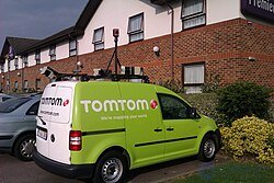
This TomTom mapping van is equipped with five lidar sensors on a roof rack.
Airborne lidar sensors are used by companies working in the field of remote sensing. They can be used to create a DEM (digital elevation model) or a DEM (digital elevation model). This is a fairly common practice for large areas, since an aircraft can acquire data from a distance of 3–4 km (2–2 km) .+A swath 1 ⁄ 2 mile (1 ⁄ 2 mile) wide in a single pass. Higher vertical accuracy, better than 50 mm (2 inches), can be achieved with a lower pass, even over forests, where it allows determination of canopy height as well as ground surface height. Typically, georeferencing the data to WGS (the World Geodetic System) requires a GNSS receiver set up at a geographically referenced control point. [ 162 ]
Lidar is also used in hydrographic surveying . Depending on water clarity, lidar can measure depth from 0.9 to 40 m (3 to 131 ft) with a vertical accuracy of 15 cm (6 in) and horizontal accuracy of 2.5 m (8 ft). [ 163 ]
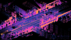
Point cloud obtained from surveying a moving vehicle with a single Ouster OS1 lidar
Lidar has been used in the railway industry to generate asset condition reports for asset management, and by transportation departments to assess road condition. CivilMaps.com is a leading company in this field. Lidar has been used in adaptive cruise control (ACC) systems for automobiles. Systems such as Siemens, Hella, Ouster and Cepton use a lidar device mounted on the front of the vehicle, for example on the bumper, to monitor the distance between the vehicle and any vehicle ahead of it. If the vehicle ahead slows down or is too close, ACC applies the brakes to slow the vehicle. When the road ahead is clear, ACC allows the vehicle to accelerate to a speed preset by the driver. For further examples, see the “Military” section above. A lidar-based device, the ceilometer , is used at airports worldwide to measure cloud height along runway approach paths.
Lidar can be used to increase the energy output of wind farms by precisely measuring wind speed and turbulence. Experimental lidar systems can be mounted on the nacelle of a wind turbine or integrated into a spinner to measure the incoming horizontal winds in the wake of a wind turbine and proactively adjust the blades to protect components and increase power output. Lidar is also used to characterize the incoming wind resource for comparison with the energy output of a wind turbine, in order to verify wind turbine performance by measuring the turbine's power curve. Wind farm optimization can be considered a topic within applied wind engineering . Another aspect of lidar use in wind energy is the application of computational fluid dynamics to lidar-scanned surfaces to assess wind potential , which can be used for optimal siting of wind farms.
Lidar can also be used to help planners and developers optimize solar photovoltaic systems at the city scale by identifying suitable rooftops and by determining shading losses . Recent efforts in airborne laser scanning have focused on ways to estimate the amount of sunlight incident on the vertical facades of buildings, or by incorporating more detailed shading losses that account for the effects of vegetation and more extensive surrounding terrain.
Modern racing simulation games, such as rFactor Pro , iRacing , Assetto Corsa and Project CARS, increasingly use race tracks reproduced from three-dimensional point clouds obtained through lidar surveys, resulting in surfaces reproduced with centimeter- or millimeter-level accuracy in the game's three-dimensional environment.
The 2017 exploration game Scanner Sombre by Introversion Software uses lidar as a fundamental game mechanic.
In the game Build the Earth, lidar is used to create accurate landscape renders in Minecraft , in order to account for any errors (mostly related to elevation) in the default generation. The landscape rendering process in Build the Earth is limited by the amount of data available for a region, as well as by the speed of converting the file into block data.
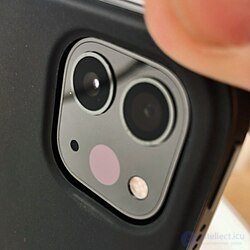
Lidar scanner on the 4th-generation iPad Pro
The video for Radiohead's 2007 song “ House of Cards ” is considered the first instance of real-time 3D laser scanning being used to record a music video. The range data in the video was obtained not only with lidar, but also with structured-light scanning.
In 2020, Apple introduced the fourth-generation iPad Pro with a lidar sensor integrated into the rear camera module , specifically designed for augmented reality (AR). This feature was later included in the iPhone 12 Pro line and subsequent Pro models] On Apple devices, lidar complements Night mode portrait photography, speeds up autofocus, and improves accuracy in the Measure app.
In 2022, the game show “Wheel of Fortune” began using lidar technology to track the movements of Vanna White's hand over the puzzle board in order to reveal letters. This technology was first used in the premiere episode of season 40.
In flash lidar, the entire field of view is illuminated by a single wide, divergent laser pulse. This differs from conventional scanning lidar, which uses a collimated laser beam , illuminating one point at a time, with the beam raster-scanned to illuminate the field of view point by point. This illumination method also requires a different detection scheme. Both scanning and flash lidar use a time-of-flight camera to collect information about both the three-dimensional location and the intensity of the light incident on it in each frame. However, in scanning lidar this camera contains only a single-point sensor, whereas in flash lidar the camera contains either a one-dimensional or two-dimensional array of sensors , each pixel of which collects three-dimensional location and intensity information. In both cases, depth information is gathered using the time of flight of the laser pulse (i.e., the time required for each laser pulse to reach the target and return to the sensor), which requires synchronization of the laser pulses and the camera's capture. This results in a camera that photographs distance rather than color. Flash lidar is particularly advantageous compared to scanning lidar when the camera, the scene, or both are moving, since the entire scene is illuminated simultaneously. In the case of scanning lidar, motion can cause “jitter” due to the time interval involved in scanning the scene with the laser.
As with all types of lidar, the onboard illumination source makes flash lidar an active sensor. The returned signal is processed by embedded algorithms to produce a nearly instantaneous 3D visualization of the objects and terrain features within the sensor's field of view. The laser pulse repetition rate is sufficient to produce high-resolution, high-accuracy 3D video. The sensor's high frame rate makes it a useful tool for various applications requiring real-time visualization, such as high-precision remote landing operations. By immediately returning a 3D elevation mesh of the target terrain, the flash sensor can be used to determine optimal landing zones in autonomous spacecraft landing scenarios.
Long-range viewing requires a powerful light pulse. The power is limited to levels that do not damage the retina. The wavelength must not have a harmful effect on human vision. However, inexpensive silicon imagers do not read light in the eye-safe spectrum. Instead, gallium arsenide -based imagers are required, which can increase the cost to $200,000. Gallium arsenide — is the same compound used to manufacture the expensive, high-efficiency solar panels commonly used in space technology.
Computer stereo vision has proven to be a promising alternative to lidar for close-range observation. When needed, it is significantly more cost-effective.
The main potential hazard of lidar — is the laser.
It can cause:
damage to the retina from direct or reflected beam exposure;
skin burns with high-power models (usually industrial or laboratory units).
| Class | Description | Measures |
|---|---|---|
| 1 | Safe under normal operation | Can be used without restriction |
| 1M / 2 / 2M | Safe under diffuse light, but hazardous when using optics (binoculars, lenses) | Do not look through optical instruments |
| 3R / 3B | Hazardous to eyes when viewed directly | Use protective eyewear, shields |
| 4 | Hazardous to eyes and skin, fire risk possible | Strict safety measures and personnel training |
Most commercial lidars (Velodyne, Ouster, Hesai, Livox, etc.) fall under class 1 or 1M, meaning they are safe under normal operation, but still require caution when tested without a housing.
Lidar power supply may be 12–48 V, sometimes higher.
Incorrect wiring — risks short circuits, overheating, electric shock.
Mandatory:
use certified power supplies;
check wire insulation;
work with the power switched off when connecting.
3. Mechanical hazard
Some lidars contain rotating elements (for example, a rotating head for 360° coverage):
risk of pinching fingers or entangling cables;
imbalance possible following a mechanical impact.
Use protective covers, do not touch moving parts during operation.
4. Thermal and fire risks
Powerful lidars and their drivers can overheat;
Dust, fabric or plastic nearby — fire risk.
Ensure ventilation, do not block cooling vents, keep away from flammable materials.
5. Software and operational risks
Incorrect calibration or software errors can lead to hazardous actions by the robot/vehicle;
False distance data is possible → navigation failures.
Verify results, have backup sensors and emergency stop mechanisms.
Before starting work:
Review the device's data sheet and its laser class;
Check the integrity of cables, housing, connectors;
Make sure there are no mirrors, glass, or reflective surfaces nearby.
During operation:
Do not look into the emitting aperture;
Do not use optical instruments to observe the beam;
Operate only with protective covers closed;
Do not touch rotating parts.
After operation:
Switch off the power before moving or cleaning;
Store in a dry, clean place;
Check calibration and the error log.
Lidars use high-intensity laser pulses (usually invisible — near-infrared range 850–1550 nm).
If the lens of a video camera, photo camera, or optical instrument (including a microscope, thermal imager, spectrometer, etc.) is pointed directly at an active lidar, damage to the sensor array is possible.
Damage mechanism
The laser beam (or its concentrated reflection) enters the camera lens.
The optical system focuses the energy onto a small area of the CCD/CMOS sensor.
Even a short pulse can cause:
burned-out pixels (bright “dead” spots);
gradual degradation of sensitivity of the sensor;
permanent “blooming” of a section of the image;
in the worst case — complete sensor failure.
Photo and video cameras (including DSLR and mirrorless);
Smartphone cameras;
Scientific and industrial cameras;
Thermal imagers, spectrometers;
Other lidars (mutual irradiation during calibration!).
Depends on:
the lidar's laser class (the higher, the more hazardous);
the wavelength (905 nm is especially hazardous — invisible, but focused by optics);
the distance (the closer, the higher the energy density);
whether the camera has filters or protective glass.
Even a class 1 lidar can damage a camera if pointed directly into the lens at close range (1–2 m).
Never point an operating lidar at optical instruments.
If joint operation is required (lidar + camera):
Use a viewing angle that excludes direct beam exposure;
Apply IR cut-off filters in front of the camera;
Separate the sensors by height or tilt angle;
Operate at a safe distance (usually >5 m).
During setup and testing — keep lens caps on.
If filming is taking place in the lidar's zone, switch it on only after all cameras are on and exposure has stabilized, to rule out an accidental focused pulse.
For industrial lidars of class >1 — use laser safety goggles matching the wavelength (usually 905 nm or 1550 nm).
Post laser hazard warning signs in the laboratory.
For autonomous machines — always have a mechanical emergency stop button (E-stop).
Comply with GOST IEC 60825-1-2013 or EN 60825-1:2014.
Часть 1 Lidar (Light Detection and Ranging)
Часть 2 Variants - Lidar (Light Detection and Ranging)

Comments