
Lecture
Это продолжение увлекательной статьи про беспилотный летательный аппарат.
...
/ data-auto-open loading="lazy" alt="Unmanned Aerial Vehicle (UAV, Drone). The Quadcopter">
UAV manufacturers often build in certain autonomous operations, such as:
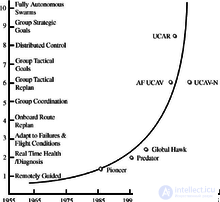
Full autonomy is available for specific tasks, such as in-flight refueling [87] or battery swapping on the ground; but higher-level tasks require greater computational, sensing, and actuation capabilities. One approach to quantifying autonomous capabilities is based on OODA terminology, proposed by the U.S. Air Force Research Laboratory in 2002 and used in the table below: [88]
| Level | Level Descriptor | Observe | Orient | Decide | Act |
|---|---|---|---|---|---|
| Perception / situational awareness | Analysis / coordination | Decision-making | Capability | ||
| 10 | Fully autonomous | Aware of everything in the battlespace | Coordinates as required | Capable of complete independence | Requires little guidance to operate |
| 9 | Battlespace swarm cognizance | Infers intent in the battlespace - own intent and that of others (friend and foe).
Complex / contested environment - onboard tracking |
Assigned group strategic goals
Estimated enemy strategy |
Distributed tactical group planning
Individual determination of tactical goal Individual planning / execution of tasks Select tactical targets |
Group achieves strategic goal without supervisor involvement |
| 8 | Battlespace cognizance | Infers proximity - own intent and that of others (friend and foe)
Reduces dependence on external data |
Assigned group strategic goals
Estimated enemy tactics ATR |
Coordinated tactical group planning
Individual planning / execution of tasks Select target of opportunity |
Group achieves strategic goal with minimal supervisory control
(example: go hunt SCUDs) |
| 7 | Battlespace knowledge | Short-track awareness - history and projection of battle events
Data in limited range, time frame, and numbers Limited inference, augmented by off-board data |
Assigned tactical group goals
Estimated enemy track |
Individual planning / execution of tasks to achieve goals | Group achieves tactical goals with minimal supervision |
| 6 | Real time
Multi-vehicle coordination |
Long-range awareness - onboard sensing at long distances,
augmented by off-board data |
Assigned tactical group goals
Enemy track detected / estimated |
Coordinated trajectory planning and execution to achieve goals - group optimization | Group achieves tactical goals with minimal supervision
Possible: close airspace separation (+/- 100 yards) for AAR, formation in safe conditions |
| 5 | Real time
Multi-vehicle coordination |
Sensed awareness - local sensors to detect others,
Fused with external data |
Tactical group plan assigned
RT Health Diagnosis - ability to compensate for most failures and flight conditions; Ability to predict the onset of failures (e.g., Prognostic Health Mgmt) Group diagnostics and resource management |
Onboard trajectory replanning - optimization for current and predicted conditions
Collision avoidance |
Autonomous execution of an externally assigned tactical plan
Medium vehicle airspace separation (hundreds of yards) |
| 4 | Fault / event adaptation
Vehicle |
Deliberate awareness - allies pass along data | Tactical group plan assigned
Assigned rules of engagement RT Health Diagnosis; ability to compensate for most failures and flight conditions - inner-loop changes are reflected in outer-loop characteristics |
Onboard trajectory replanning - event-driven
Autonomous resource management Conflict resolution |
Autonomous execution of an externally assigned tactical plan
Medium vehicle airspace separation (hundreds of yards) |
| 3 | Robust response to real-time faults / events | Health / status history and models | Tactical group plan assigned
RT Health Diagnosis (what is the scope of the problems?) Ability to compensate for most failures and flight conditions (e.g., adaptive inner-loop control) |
Evaluate status against required mission capabilities
Abort / RTB insufficient |
Autonomous execution of an externally assigned tactical plan |
| 2 | Changeable mission | Health / status sensors | RT Health diagnosis (Do I have a problem?)
External replanning (as required) |
Execute preprogrammed or uploaded plans
in response to mission and health status |
Autonomous execution of an externally assigned tactical plan |
| 1 | Execute preplanned
Mission |
Preloaded mission data
Flight control and navigation sensing |
Pre / post-flight BIT
Status report |
Programmed mission and abort plans | Wide airspace separation requirements (miles) |
| 0 | Remotely
Piloted Vehicle |
Flight control (attitude, speed) sensing
Nose camera |
Telemetry data
External pilot commands |
No data | Controlled by an external pilot |
Intermediate levels of autonomy, such as reactive autonomy, and higher levels employing cognitive autonomy, have to some extent already been achieved and are very active areas of research.
Reactive autonomy, such as collective flight, real-time collision avoidance, wall following, and corridor centering, depends on communication links and the situational awareness provided by range sensors: optical flow, [89] lidars (light radars), radars, and sonars.
Most range sensors analyze electromagnetic radiation reflected from the environment and reaching the sensor. Cameras (for visual flow) act as simple receivers. Lidars, radars, and sonars (using mechanical sound waves) emit and receive waves, measuring the round-trip travel time. UAV cameras do not require emission power, which reduces overall power consumption.
Radars and sonars are mainly used for military purposes.
Reactive autonomy has, in some forms, already reached consumer markets: it may become widely available in less than a decade. [63]
SLAM combines odometry and external data to represent the world and the UAV's position in it in three dimensions. Outdoor navigation at high altitude does not require large vertical fields of view and can rely on GPS coordinates (which makes it simple mapping rather than SLAM). [90]
Two related research areas are photogrammetry and lidar, especially in 3D environments at low altitudes and indoors.
A robot swarm refers to a network of agents capable of dynamically changing configuration as elements leave or join the network. They provide greater flexibility than cooperation among a few agents. A swarm can open the way to data fusion. Some bio-inspired flocking behaviors use steering and flocking algorithms.
In the military sector, American Predators and Reapers are designed for counterterrorism operations and combat zones where the enemy lacks sufficient firepower to shoot them down. They are not designed to face air defenses or engage in air combat. In September 2013, the head of the US Combat Air Command stated that unmanned aircraft were currently "useless in a contested environment" unless manned aircraft were present to protect them. A 2012 Congressional Research Service (CRS) report suggested that in the future UAVs might perform tasks beyond reconnaissance, surveillance, intelligence gathering, and strikes; the CRS report listed "air-to-air" combat among possible future undertakings ("the more difficult task of the future"). The Department of Defense's Unmanned Systems Integrated Roadmap for 2013–2038 envisions a more important place for UAVs in combat. Challenges include extended capabilities, human-UAV interaction, managing an increased flow of information, increased autonomy, and the development of specialized munitions for UAVs. DARPA's system of systems project [97] or the work of General Atomics may foreshadow future warfare scenarios, the latter unveiling the Avenger swarm equipped with an area-defense system using a high-energy liquid laser (HEL). [98]
Cognitive radio technology may have applications in UAVs. [99]
A cognitive radio system (Cognitive Radio System, CRS) — a radio system capable of gathering information about its own operating characteristics and, based on this data, adjusting its operating parameters
UAVs can use distributed neural networks. [63]
As of 2020, seventeen countries have UAVs in service, and more than 100 countries use UAVs for military purposes. [100] The global military UAV market is dominated by companies based in the US and Israel. In terms of sales in 2017, the US share of the military market was more than 60%. Four of the five largest military UAV manufacturers are American, including General Atomics, Lockheed Martin, Northrop Grumman, and Boeing, followed by the Chinese company CASC. [101]Israeli companies mainly focus on small UAV surveillance systems, and by number of drones, Israel exported 60.7% (2014) of the UAVs on the market, while the United States exported 23.9% (2014); the main importers of military UAVs are the United Kingdom (33.9%) and India (13.2%). In the United States alone, more than 9,000 military UAVs were in operation in 2014. [102] General Atomics is the dominant manufacturer of the Global Hawk and Predator / Mariner product lines.
The civilian drone market is dominated by Chinese companies. The Chinese drone manufacturer DJI alone held a 74% share of the civilian market in 2018, with no other company accounting for more than 5%, and with a forecast of $11 billion in global sales by 2020. [103] After a thorough review of its activities, the US Department of the Interior grounded its fleet of DJI drones in 2020, and the Department of Justice banned the use of federal funds to purchase DJI and other foreign-made UAVs. [104] [105] DJI is followed by the Chinese company Yuneec, the American company 3D Robotics, and the French company Parrot, with a significant gap in market share. [106]As of March 2018, more than a million UAVs were registered with the US Federal Aviation Administration (878,000 hobbyist and 122,000 commercial). NPD's 2018 data indicates that consumers are increasingly buying drones with more advanced features, with 33-percent growth in both the $500+ and $1000+ market segments. [107]
The civilian UAV market is relatively new compared to the military one. Companies are emerging simultaneously in both developed and developing countries. Many early-stage startups have received support and funding from investors, as in the United States, and from government agencies, as in the case of India. [108] Some universities offer research and educational programs or degrees. [109] Private organizations also provide online programs and personal training programs for both recreational and commercial use of UAVs. [110]
Consumer drones are also widely used by military organizations around the world because of the cost-effectiveness of consumer products. In 2018, the Israeli military began using DJI Mavic and Matrice series UAVs for light reconnaissance missions, since civilian drones are easier to use and have higher reliability. DJI unmanned aerial vehicles are also the most widely used commercial unmanned aerial system used by the US Army. [111] [112] DJI surveillance drones have also been used by Chinese police in Xinjiang since 2017.
By 2021, the global UAV market will reach $21.47 billion, with the Indian market reaching $885.7 million [115].
Lighted drones are beginning to be used in night displays for artistic and advertising purposes.
AIA reports that large cargo and passenger drones must be certified and introduced within the next 20 years. Large sensor-equipped drones are expected from 2018; short-haul, low-altitude cargo flights outside cities from 2025; long-haul cargo flights by the mid-2030s, followed by passenger flights by 2040. R&D spending is expected to grow from a few hundred million dollars in 2018 to $4 billion by 2028 and $30 billion by 2036 [116].
As global demand for food production grows exponentially, resources are being depleted, farmland is shrinking, and agricultural labor is becoming increasingly scarce, there is an acute need for more convenient and intelligent agricultural solutions than traditional methods, and progress in the agricultural drone and robotics industry is expected to accelerate. [117] Agricultural drones have been used in regions such as Africa to build sustainable agriculture. [118]
Police can use drones for applications such as search and rescue operations and traffic monitoring. [119]
Flapping-wing ornithopters that mimic birds or insects are an area of research in micro-UAVs. Their inherent stealth makes them well suited for spy missions.
The Nano Hummingbird is commercially available, while fly-inspired micro-UAVs weighing less than 1 gram, although using a tether, can "land" on vertical surfaces. [120]
Other projects include unmanned "beetles" and other insects. [121]
Research is studying miniature optical-flow sensors called ocelli, mimicking the compound eyes of insects formed from multiple facets, which can transmit data to neuromorphic chips capable of processing optical flow as well as differences in light intensity.
продолжение следует...
Часть 1 Unmanned Aerial Vehicle (UAV, Drone). The Quadcopter
Часть 2 - Unmanned Aerial Vehicle (UAV, Drone). The Quadcopter
Часть 3 Autonomy - Unmanned Aerial Vehicle (UAV, Drone). The Quadcopter
Часть 4 - Unmanned Aerial Vehicle (UAV, Drone). The Quadcopter
Часть 5 Basic principles - Unmanned Aerial Vehicle (UAV, Drone). The Quadcopter
Часть 6 - Unmanned Aerial Vehicle (UAV, Drone). The Quadcopter
Часть 7 Capabilities - Unmanned Aerial Vehicle (UAV, Drone). The Quadcopter
Часть 8 - Unmanned Aerial Vehicle (UAV, Drone). The Quadcopter
Часть 9 Applications of unmanned aerial vehicles - Unmanned Aerial Vehicle (UAV,

Comments