
Lecture
In warm air, isobaric surfaces are located at greater distances from one another than in cold air, so a closed circulation of air arises.
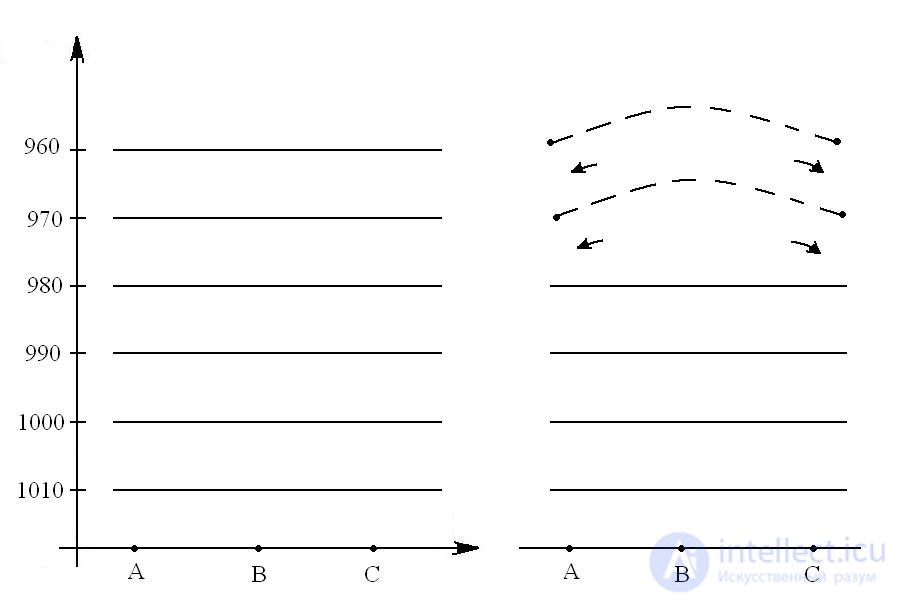
Fig. 14 Thermal circulation of air masses
If the temperature at sections A, B, C is the same, then the change of temperature with height is also the same. In this case the isobaric surfaces are arranged parallel to one another, at all heights there is no horizontal gradient, and there is no horizontal motion of air. If, for some reason, the temperature rises in region B and spreads to the overlying layers, the position of the isobaric surfaces will change. They begin to rise and diverge, that is, a horizontal pressure gradient arises. At the upper levels the pressure over region B turns out to be higher than over regions A and C, so air begins to move from region B toward regions A and C. This, in turn, leads to a change of pressure at the lower levels; as a result of the outflow of air, the pressure in region B falls, while in regions A and C it rises. The position of the isobars also changes at the lower levels.
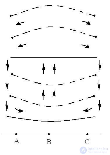
In region B the isobaric surfaces at the lower levels descend, while in regions A and C they rise. Now a horizontal baric pressure gradient also arises at the lower level: air from regions A and C will move toward region B. Thus, between the heated region B and the unheated regions A and C, a thermal circulation of air arises, comprising the following links:
1) Above the warm surface there arises an
upward motion
2) Above the colder surface a downward one
3) At the Earth's surface, horizontal motion of air from the cold sections A and C toward the warm B.
4) At high levels, motion from the heated
section B toward the cold A and C.
Air currents arising at the Earth's surface are characteristic only of particular geographic regions and are therefore called local winds (breezes, mountain-valley winds, glacier winds).
The general circulation of the atmosphere is the totality of the main air currents on the globe. The main large-scale atmospheric movements included in the general circulation of the atmosphere are:
Air currents caused by temperature differences between latitudinal zones near the Earth's surface and at altitude;
Jet streams;
Air currents in cyclones and anticyclones, which ensure interlatitudinal exchange of air;
Trade winds;
Monsoons;
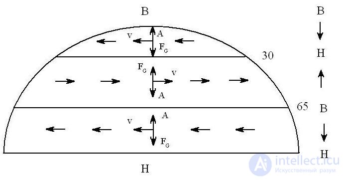
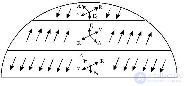
Fig. 15 Circulation in the atmosphere above the friction layer and in the friction layer
Air circulation over the polar regions is due to the influence of the relatively higher pressure over the poles and the comparatively low pressure at latitudes 60 - 65. Accordingly, the horizontal pressure gradient is directed from the poles toward the temperate latitudes. The winds have an easterly direction. In the friction zone the wind is deflected by an angle of less than 90 and takes on a northeasterly direction. At latitudes of 30-35 (temperate latitudes), above the friction layer the wind has a westerly direction, while in the friction layer it is southwesterly. At the equator in the Northern Hemisphere, above the friction layer the wind has an easterly direction, while in the friction layer it has a northeasterly direction.
Under real conditions the circulation of the atmosphere is complicated by cyclonic activity, which continually develops and displaces large-scale atmospheric disturbances (cyclones and anticyclones). They usually move from west to east. During this displacement, an exchange of air masses takes place both in the meridional direction and vertically. The northeasterly winds in the Northern Hemisphere and the southeasterly winds in the Southern Hemisphere are called trade winds.
Trade winds – constant, steady winds that hardly change their direction over the course of the year, having a speed at the Earth's surface of 5-6 m/s and a vertical extent of 2-4 km.
Jet streams – a strong, narrow air current with an almost horizontal axis, observed in the upper troposphere and stratosphere and characterized by large vertical and horizontal gradients of wind speed. The lower speed limit is 30 m/s, the upper 200 m/s, the width of the current ranges from 300 to 3000 km, the vertical extent from 8 to 12 km, and the length up to several thousand km.
Monsoons – steady air currents in certain regions of the Earth that reverse their prevailing direction twice a year. There are winter and summer monsoons. In the transitional seasons (autumn and spring), when the seasons change, the stability of the wind regime is disrupted.
The monsoon circulation reverses its direction in connection with the inter-seasonal change in the distribution of atmospheric pressure. Monsoons are observed in those regions of the Earth where, during one season, a cyclone or anticyclone predominates, and during the other season the opposite baric system predominates. Where cyclones and anticyclones frequently replace one another during a single season, monsoons are not observed (most of Europe).
Powerful monsoons occur in the northern part of the Indian Ocean and in South Asia, where the inter-seasonal changes of the hemisphere are intensified by the huge Asian continent, strongly heated in summer and strongly cooled in winter (in winter – the northeasterly monsoon; in summer – the southwesterly monsoon).
Extratropical monsoons are related to the fact that over certain continents, stable areas of elevated pressure predominate in winter, and areas of reduced pressure in summer. In winter, owing to anticyclonic activity over land, the winds are directed toward the sea. In summer, winds blow from the sea toward land. Extratropical cyclones are well expressed in the Far East, China, and Japan. In the Far East, the northwesterly monsoon brings dry continental air and makes winter severe and largely cloudless. The summer monsoon (southeasterly) brings humid and cool air.
It should be noted that as early as 200 years ago, the simplest schemes of the general circulation of the atmosphere were drawn up. The basic principles of these schemes have not lost their significance to this day.
Atmospheric circulation proceeds as follows (Fig. 16): air, heated over the equator, rises and moves toward the North Pole; as it moves, owing to the rotation of the Earth, it deviates more and more from straight-line motion, and at a latitude of about 30 it takes on a west-to-east direction. In the subtropical latitudes, at heights of 3-5 km above the Earth's surface, there is a zone of westerly winds; at latitude 35, air accumulates and a belt of elevated pressure forms, from which air spreads in both directions, subject to the action of the Coriolis force. Air currents heading toward the equator have a northeasterly direction (trade winds).
North of the belt of elevated pressure, a system of southwesterly winds forms at the Earth's surface, which predominate in the temperate latitudes.
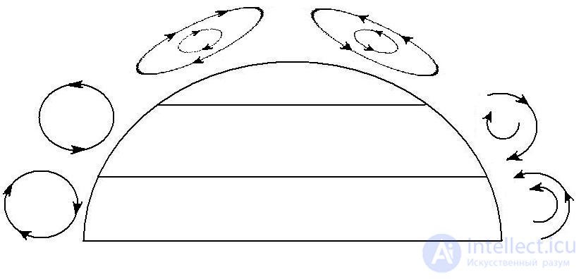
Fig. 16 Atmospheric circulation in the Northern Hemisphere
At the pole, air cools under the action of low temperatures, sinks, and spreads to the south, and above the friction layer the air acquires an east-to-west direction. At latitude 65, this air meets the air of the temperate latitudes, and the air masses rise.
Thus, three vertical «wheels» of atmospheric circulation are formed.
Since the Earth's surface is not homogeneous and is divided into continents and oceans, which heat up and cool differently, the belts of high and low pressure are divided into areas of elevated and reduced pressure with closed isobars (cyclones and anticyclones). In summer, areas of low pressure form over the heated continents, together with the associated upward motions of air masses, while over the oceans areas of high pressure form, in which the air masses sink. In winter, the reverse picture is observed.
Cyclones and anticyclones are especially clearly manifested in the temperate latitudes in winter, when the temperature contrasts between continents and oceans are particularly great.

Comments