Lecture
The planning of populated areas in material architecture is a complex of measures aimed at creating a comfortable, functional and sustainable environment for life, work and recreation of people. The planning is based on the principles of rational placement of territories, infrastructure, residential and public buildings, taking into account the natural, historical, cultural, social and economic features of the region. The spatial organization of a populated area includes zoning of the territory (residential, industrial, recreational areas), formation of a street and road network, placement of utilities and public transport. Particular attention is paid to the accessibility of social facilities - schools, hospitals, cultural and sports institutions, as well as the connectivity of the urban environment, ensuring convenient movement and visual integrity. The planning takes into account the scale of development, population density, landscape features and climate, as well as development prospects - population growth, expansion of infrastructure, change in the functions of individual territories. In addition, the environmental component plays an important role: preservation of natural areas, minimization of anthropogenic impact, introduction of green infrastructure. An integrated approach to the planning of populated areas is aimed at creating a harmonious, sustainable and livable space that meets modern urban requirements and the needs of the local community.
Depending on the number of people living in a given territory and the predominant nature of the population’s occupation, places of residence are divided as follows: cities with a population of 5 thousand people or more;
Cities are divided according to their economic profile into industrial, port, resort, railway hubs, scientific centers and others.
According to their administrative, political and cultural significance, cities are classified as capital cities, administrative centers of regions, districts, and others.
The concentration of residents in cities is a sign of our times. There are 150 cities on Earth with a population of more than 1 million people, more than 1/6 of the entire population of the planet lives in them.
The city layout depends on the nature of the main production activity, climate, terrain and other factors. The main planning schemes of cities are compact and dispersed.
The construction of new and expansion of existing settlements is carried out on the basis of plans for the development of the national economy and taking into account the rational placement of productive forces.
The basis for the design and construction of populated areas is the general plan, which links social, economic, architectural, sanitary, engineering tasks with current standards, for a long-term period of 20 years or more, and for the first stage of construction - 5 years.
A master plan is a strategic document for the spatial development of a settlement, defining the principles, goals and directions of its urban development organization for the long term (usually 15–25 years). It is the basis for architectural and construction design, territory management and investment decision-making.
The master plan includes the following key elements:
Functional zoning is the determination of the purpose of territories: residential areas, industrial zones, public and recreational spaces.
Street and road network - the formation of a system of transport links: highways, local roads, pedestrian routes, transport hubs.
The development structure includes parameters of density, number of storeys, building typology, landscape features and urban morphology.
Environmental issues - protection of natural resources, landscaping, water bodies, climate parameters.
Placement of social facilities - schools, kindergartens, medical institutions, sports complexes, cultural institutions.
Engineering infrastructure – water supply, sewerage, electricity and heat supply networks, communications and digital technologies.
Development forecast - scenarios of demographic and economic growth, development of new territories, modernization of existing ones.
A master plan is not just a map, but a model of a future city or town. It shapes people's lifestyles, influences the quality of the environment, social integration, economy and sustainability of the territory. The plan can be revised as conditions change and when urban development policy is updated.
Before designing populated areas, the natural and economic conditions of the area are comprehensively studied and a technical and economic comparison of options is made.
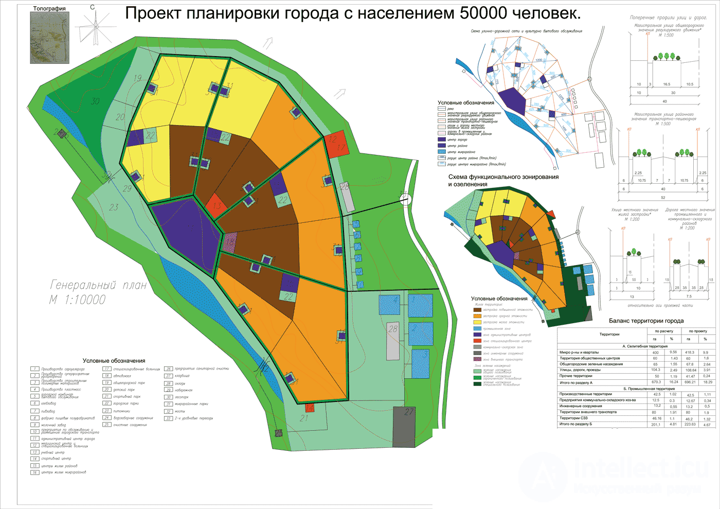
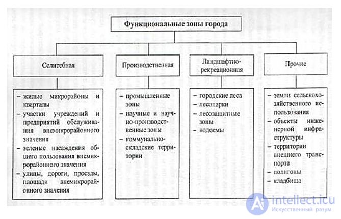
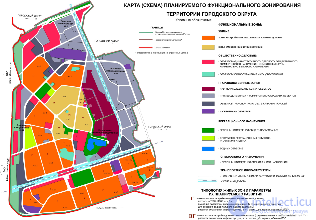
The city territory is divided into zones depending on the purpose. Residential (residential) zone. It contains residential and public buildings, parks, squares, as well as public utility enterprises that do not emit hazardous waste.
Industrial zone. Industrial enterprises, their transport facilities, and warehouses are located here.
Communal and warehouse zone. It contains bus and tram depots, garages, water supply and sewerage facilities, warehouses of trade and business organizations, their railway lines and highways.
External transport zone. It contains port facilities, railway stations, airfields, sea and river terminals.
Reserve areas and recreation zones should be provided in the territories adjacent to the city.
The mutual arrangement of zones should ensure their good communication so that the city is a single organism, and the population is provided with the most favorable working and living conditions.
In cities of different sizes, individual zones may be located in one or several places.
When designing cities, the location of industrial and residential zones, it is necessary to take into account the direction of the prevailing winds. For this purpose, a "wind rose" is used.
The residential area is divided into the city center and residential areas consisting of microdistricts. The city center usually includes the main square, where the buildings of city-wide institutions are located. Residential areas are formed depending on the size of the city, the number of storeys of the building and other conditions. The public center of the district is formed by administrative institutions of district significance, cultural and household institutions of periodic use.
Microdistrict is the main structural unit of development. It is a complete complex with a full set of cultural and household institutions and enterprises of daily services. The population of the microdistrict is 3-4 thousand people. in low-rise development and 6-8 thousand people. in high-rise development. The corresponding areas of the territory of microdistrict 3-4 are 15-20 hectares and 20-30 hectares. The territory of the microdistrict should not be crossed by transport highways, it has passages for the needs of the microdistrict.
The distances between buildings are called gaps. They are established in accordance with sanitary and fire safety regulations, depending on the height of the taller building, which should not shade the neighboring building, and depending on the degree of fire resistance of the buildings.
The sanitary protection zone is the territory between the sources of industrial hazards and the boundary of residential development. The size of the zone is determined depending on the class of enterprises from 1000 m to 50 m. This territory must be landscaped and greened. Individual buildings and structures with a lower hazard class may be located here. Sports facilities, parks, children's institutions, schools and other institutions may not be located in this zone.
The development of the microdistrict is decided taking into account the most favorable insolation, ventilation, isolation from noise and dust. For this purpose, recreation areas with sports grounds are arranged, passages along driveways and pedestrian roads are landscaped.
Greenery purifies the air, protects from winds and city noise. The green area should be at least 40% of the microdistrict territory. There should be at least 10 m2 of green space per resident.
The layout of cities is determined by the nature of the road and street network, which acts as the city's arteries. Streets and roads are transport communications and routes for people to move. Along them run water supply, sewerage, energy supply, communications and other networks.
The following types of road and street network schemes are distinguished:
Depending on the purpose of the road and street, there are main roads and streets of local importance. Main roads are the main routes of urban transport - citywide, district importance, freight transport roads.
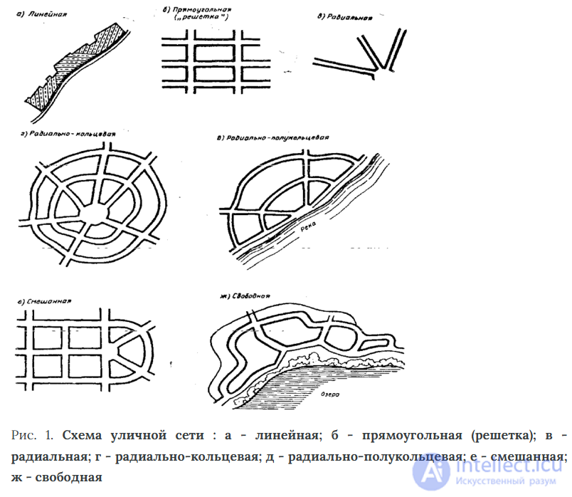
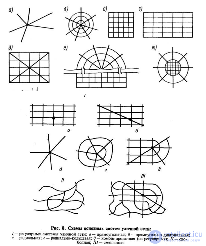
Streets and roads of local importance can be residential, industrial, pedestrian, or passageways.
The road network in cities and towns should be conveniently connected to intercity highways.
Depending on their purpose, squares are divided into main, district, transport, railway station, and local areas.
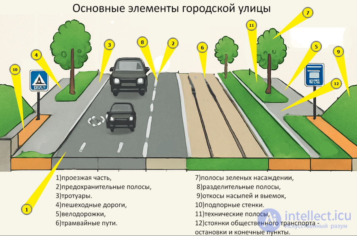
The main elements of a city street are as follows:
The boundaries of city streets, roads, buildings, and parks are called "red" lines.
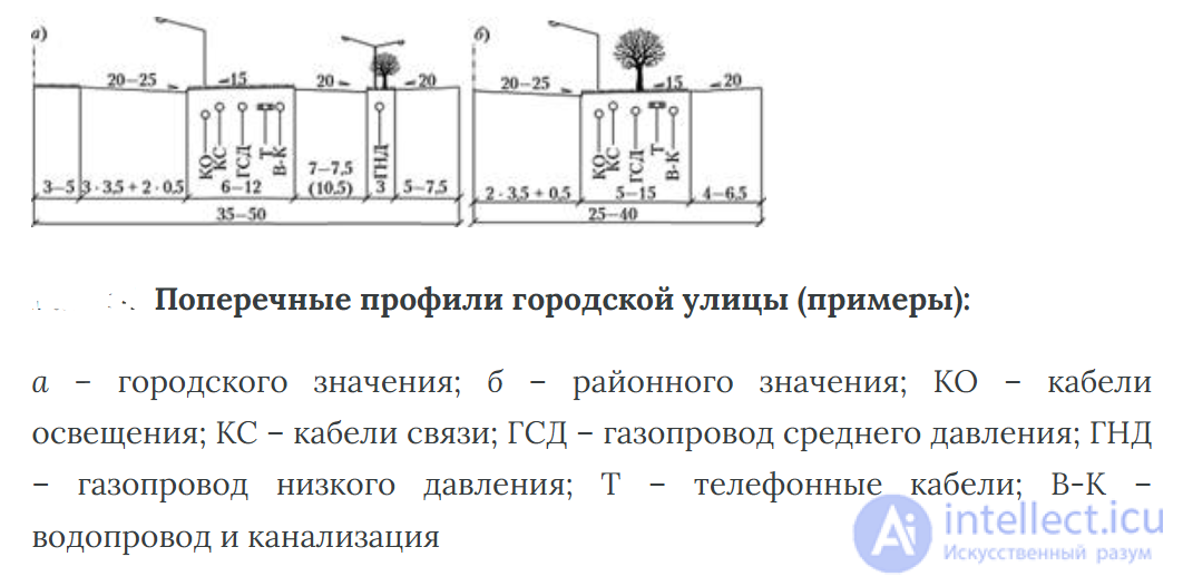
The width of streets depends on many factors: the intensity of traffic and pedestrians, the terrain, the method of draining rain and melt water, the placement of underground utility networks, etc. Green strips are used to separate street elements: the roadway from sidewalks, sidewalks from built-up areas, etc.
For laying underground communications, dividing islands and strips, technical strips are usually used. The most rational and progressive laying of networks is the combination in a common trench and in a common collector made of precast reinforced concrete structures.
The fight against urban noise is aimed at removing noise sources from buildings, using the terrain, green spaces, and also combating noise at its source.
For the technical and economic assessment of the development, the following indicators are calculated:
1) the gross density of the housing stock is the ratio of the total area of all floors to the area of the microdistrict.
2) the density of residential development as the ratio of the area of houses to the living area of the microdistrict.
3) area of green spaces.
The main focus for rational planning and development of residential areas is the choice of number of storeys. Two-storey development is convenient in small towns and villages, 10-16 storeys - in the largest cities.
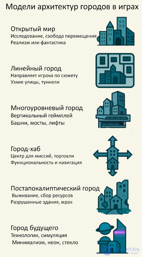
Urban theory in video games is not just about “construction simulators,” but also about how digital worlds model, critique, and reimagine real cities.
Empirical simulations: SimCity, Cities: Skylines use simplified models of the economy, transport and ecology - a kind of "urbanist sandbox".
City archetypes: Games often embody cultural notions - a cyberpunk metropolis, a utopian eco-village, or a post-apocalyptic ruin.
Invisible Urbanism: Dark Souls, Dishonored, Bloodborne design cities imbued with narrative – space becomes a story.
| City model | Game specifics | Architecture and style |
|---|---|---|
| Open world | Exploration, freedom of movement | Realism or fantasy |
| Linear city | Guides the player through the story | Narrow streets, tunnels |
| Multi-level city | Vertical gameplay | Towers, bridges, elevators |
| Hub city | Center for missions, trade | Functionality and navigation |
| Post-apocalyptic city | Survival, resource gathering | Destroyed buildings, darkness |
| City of the Future | Technologies, Simulation | Minimalism, neon, glass |
Access hierarchy: who can go where and why? It's a matter of urban zoning — even in the GTA.
Spatial behavior of NPCs: Everyday patterns, from routes to interactions, show how the city “lives”.
The city as a puzzle or a labyrinth: in Assassin's Creed you explore verticality, in Half-Life 2 - the linear kinetics of space.
Utopia and dystopia: video games are a safe space for experimenting with political, architectural and ecological utopias (BioShock, Frostpunk).
Digital Justice: Who is Included in the City and Who is Excluded? What is “Public Space” in the Game?
Games as learning environments: Minecraft Education Edition is used in urban studies and architecture.
Mods and custom maps: Players can design their own cities - for example, in Skyrim or Cities: Skylines with mods that reflect real-world geographic areas.

Comments
To leave a comment
Video game architecture
Terms: Video game architecture