
Lecture
Subsoil (in the narrow sense of the word) is the upper part of the Earth's crust in which, at the current level of technology, minerals are extracted. Sometimes environmental literature uses the term «geological environment», which almost coincides with the concept of «subsoil».
Mineral resources - are minerals found in the Earth's subsoil as a result of geological exploration work and available for industrial development. Minerals are divided into combustible, metallic and non-metallic.
Large reserves of the main minerals are distributed among countries as follows:
1. oil - Saudi Arabia, Kuwait, Iraq:
2. natural gas - Russia, Iran, the United Arab Emirates;
3. hard coal - China, the USA, Russia;
4. iron ore - Brazil. Russia. China:
5. copper ores - Chile. USA, Zaire;
Proven iron reserves on Earth are estimated at 100 billion tons. The main reserves of iron are concentrated in America (47.8%), Africa (15.9%), Australia and Oceania (15.7%).
Proven reserves of phosphorites, estimated at 40-50 billion tons, are located in Africa (62%), America (29.1%) and Asia (5.9%).
Aluminum reserves are estimated at 20-25 billion tons. They are located in Africa (59.4%), America (19%), Australia and Oceania (11.6%).
World reserves of oil and gas amount to 136,094 million tons and 141,026 billion m3. The main oil reserves are concentrated in the Middle East (65.7%), in America (16.2%, including 3.3% in the USA) and Africa (6.1%); gas reserves - in Eastern Europe (40.2%, including 39.2% in Russia), in America (10%) and Africa (6.9%).
The mineral resource base of domestic industry (energy, fuel, chemical, construction, ferrous and non-ferrous metallurgy) is made up of deposits whose reserves have been explored and assessed with sufficient accuracy.
In Russia about 20 thousand mineral deposits have been discovered and explored, of which approximately 37% have been brought into industrial development. Russia's deposits contain over 10% of the world's proven oil reserves, approximately one third of the world's gas reserves, 12% of coal, 28% of iron ore, and a significant part of the proven reserves of non-ferrous and rare metals. In terms of proven reserves of gold, platinoids and platinum, Russia ranks second in the world, and first in diamonds and silver.
Oil production (with condensate) in Russia amounts to about 460 million tons per year, of which 330 million tons are produced in Western Siberia, 110 million tons in the Urals-Volga region, and 0.03 million tons per year on the continental shelf. The volume of oil extracted from great depths is increasing. In 1997 alone, 50 new oil fields were discovered. On average, 2.1 million tons of oil and 1.7 million tons of gas are extracted from a single field.
Mineral raw materials and mineral products obtained as a result of their extraction and subsequent processing constitute the main item of Russian exports. Exports of mineral raw materials at the end of the 1990s provided 67-70% of Russia's foreign currency earnings, with fuel and energy resources accounting for approximately half of them.
The Russian Federation's supply of mineral reserves:
Oil - 35 years, natural gas – 80, coal – 60-180, iron ore – 42, copper – 40, lead – 15, gold – 37.
Minerals of the Omsk Region
During the 20th century, 361 deposits, 95 occurrences and 311 prospective areas were identified in the Omsk Region, comprising 23 types of minerals.
Oil and gas
Areas promising for oil exploration gravitate toward the northern districts of the Omsk Region. At present 5 hydrocarbon deposits have been discovered: 4 oil deposits. Estimated oil reserves - 43.7 million tons, gas - 640 m3/thousand tons.
Non-ferrous and rare metals
Zircon-ilmenite placers (minerals of zirconium and titanium) have been known in the region since 1959. Currently the largest and most geologically studied is the Tara placer, located in the Tara district. Total placer reserves are estimated at 250 million.
PROTECTION OF SUBSOIL
Protection of subsoil refers to the scientifically grounded rational and careful use of minerals, their maximum, technically feasible and economically viable extraction, waste utilization, and elimination of damage caused to natural landscapes.
1 - There are significant losses of minerals and damage to the environment during underground mining of deposits. Coal losses (remaining in the subsoil) amount to 20-45%, losses of non-ferrous and ferrous metal ores 15-25%, mining-chemical raw materials 20-60%. With open-pit mining, losses are reduced to 12%.
2 - Losses of minerals due to imperfect extraction technology are extremely high. Currently, the share of extracted oil relative to proven reserves is 50-60%. Losses of associated gas - 20 billion tons per year (it is burned off in flares) are simply staggering.
3 - Deposits often contain, in addition to the main component, a whole range of associated inclusions. Valuable components may end up in waste dumps and pose a danger as potential sources of environmental pollution. Therefore, subsoil protection measures include the comprehensive use of resources, which provides for more complete extraction of accompanying components when mining a given mineral,
4 - Incomplete geochemical study of deposits also means that not all possible components are extracted from a deposit.
5 - Eliminating the bulk-extraction system and timely separation and sorting of ores during mining make it possible to preserve valuable components of the raw material, which yields a large economic effect.
6 - Significant losses of minerals occur during their transportation to processing and use sites. In Russia, 350 thousand km of field pipelines are in operation, on which more than 50 thousand ruptures occur annually. In Western Siberia, more than 100 thousand km of field pipelines with 30 years of service life need replacement. As a result, 2650 tons of oil from trunk pipelines and 1438 tons of oil products are spilled each year. Transportation of solid minerals is associated with smaller losses, for example, in the transport of coal. These are losses not only of the product itself - they are also linked to environmental pollution.
7 - Losses of mineral resources also occur when extracting metals from already enriched ores. Thus, in the processing of copper concentrates, metal losses reach: copper 6%, nickel 15%, cobalt 52%.
8- Comprehensive, most complete extraction and use of chemical elements makes it possible to preserve the deposit and avoid spending additional funds on treating exhaust gases, dust and industrial effluents.
9 - Dust trapped by filters is a high-quality raw material; oil and oils collected in the settling tanks of oil refineries, and at repair, transport and other enterprises, are refined and used in the national economy.
10- Recycling. Secondary raw materials can provide almost half of the volume of smelted steel. Recycling of non-ferrous metal scrap could potentially yield annually 1/5 of world copper production, more than 1/3 of tin, 1/3 of aluminum, and about 1/5 of zinc.
11. Another reserve for conservation, the use of which will preserve the subsoil, is the use of artificial substitutes for scarce mineral raw materials. Metal can be successfully replaced by plastics, wood and even stone. Judging by the pace of plastics production, polymers will soon surpass metals. In the not-too-distant past it was hard to imagine a teflon kettle, or a television without vacuum tubes.
The land area is 15 billion hectares, i.e. about a third of the Earth's surface. Of this, forests occupy 28%, deserts, glaciers, settlements and other areas with poorly developed soil cover - 45%, pastures - 17%, cultivated land - 10%, and about the same amount of land is suitable for cultivation but its use in agriculture is economically unprofitable. Thus, human nutrition is provided mainly by 1450 million hectares of cultivated soils, and for this reason they deserve careful use and thorough protection.
Soil - is the surface layer of the Earth's crust, which forms and develops as a result of the interaction of vegetation, animals, microorganisms, and parent rock, and is an independent natural formation.
The founder of scientific soil science was the Russian scientist V.V. Dokuchaev (1846-1903), who was the first to define the concepts of "soil" and "soil profile", identified the main distinctive properties, and revealed the essence of the soil-formation process. Water (soil and ground water) and human economic activity were later added to the five factors of soil formation established by V.V. Dokuchaev: parent rock, climate, relief and time, and plant and animal organisms.
Any soil can be regarded as a heterogeneous system consisting of three phases: solid (mineral skeleton, organic and biological components), liquid (soil solution) and gaseous (soil air).
The solid phase of soil contains the main store of nutrients for plants. It consists of 90 % or more of complex minerals and approximately 10 % or less of organic matter, which plays a very important role in soil fertility. Almost half of the solid phase of soil is bound oxygen, one third is silicon, more than 10 % - aluminum and iron, and only 7% - the remaining elements.
The totality of finely divided (colloidal) soil particles and organic matter forms the soil absorbing complex (SAC). The total charge of the SAC in most soils is negative, and thus it retains on its surface, in an adsorbed state, mainly positively charged ions - cations.
Soil solution - is the most mobile and active part of the soil, in which various chemical processes take place and from which plants directly absorb nutrients. Nutrient elements in the soil solution are the most accessible to plants.
Soil air serves as the main source of oxygen for the respiration of plant roots. It differs from atmospheric air in its increased carbon dioxide content and somewhat lower – oxygen content.
The structure of soils is characterized by a combination of genetic horizons. Horizons are called genetic when they formed as a result of a common soil-formation process, so that the formation of each of the horizons present in the soil is closely linked to (or even conditioned by) the formation of other horizons. This is easiest to illustrate using the structure of certain soils as an example. If a soil pit is dug (a hole excavated) with a vertical front wall, the sequence of genetic horizons becomes clearly visible on that wall.
As a result of the movement and transformation of substances, soil is divided into separate layers, or horizons, the combination of which makes up the soil profile.
S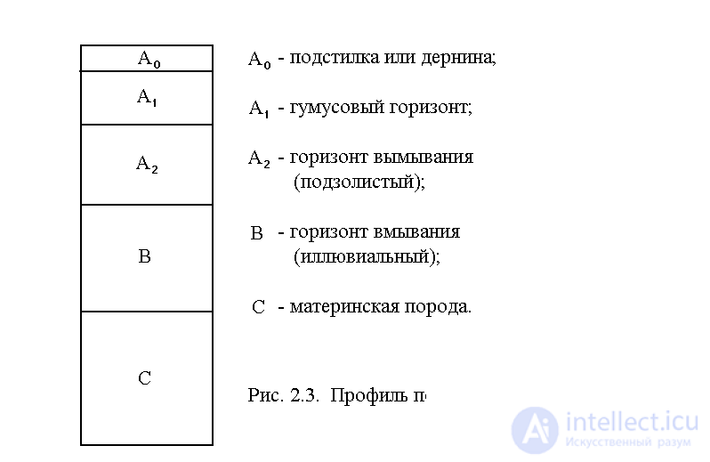 urface horizon, litter or turf, consists mostly of freshly fallen and partially decomposed leaves, twigs, animal remains, fungi and other organic matter. It is usually colored dark - brown or black. Lying beneath it is the humus horizon A1, which as a rule is a porous mixture of partially decomposed organic matter (humus), living organisms and some inorganic particles. It is usually darker and looser than the lower horizons. The bulk of the soil's organic matter and plant roots are concentrated in these two upper horizons. The soil's color can reveal much about its fertility. For example, a dark brown or black humus horizon is rich in organic matter and nitrogen. Gray, yellow or red soils contain little organic matter, and nitrogen fertilizers are needed to increase their yield.
In forest soils, beneath horizon A1 lies the low-fertility podzolic horizon A2, which has a light shade and a weak structure. In chernozem, dark chestnut, chestnut and other soil types this horizon is absent. Even deeper, in many soil types, lies horizon B-illuvial, or the horizon of washing-in. Mineral and organic substances from the overlying horizons are washed into it and accumulate there. It is most often colored brown and has greater density. Even lower lies the parent rock C, on which the soil forms.
All soil horizons are a mixture of organic and mineral elements. Over 50% of the mineral composition of soil is silica (SiO2), and the remainder may consist of alumina, and oxides of iron, magnesium, potassium, phosphorus, and calcium. Organic matter entering the soil with plant litter includes carbohydrates, proteins, fats, resins, and tannins. Organic remains in the soil mineralize to form simpler substances (water, carbon dioxide, ammonia, etc.) or turn into humus.
Through soil - the most important component of the biosphere - the ecological connections of living organisms with the lithosphere, pedosphere, and atmosphere are realized.
The most important property of soil is fertility. Soil fertility - is the set of soil properties that ensures high yields of agricultural plants, as well as the biological productivity of natural phytocenoses. Soil fertility depends on the optimal content of nutrients in it (nitrogen, phosphorus, potassium, trace elements), the degree of moisture, correct farming methods, the absence of secondary salinization, erosion processes, etc. Soil fertility is determined by the presence of humus in it.
Humus - high-molecular-weight, dark-colored organic substances of the soil. It consists of humic acids, formed as a result of the biochemical decomposition of plant and animal remains. It contains plant nutrients, which after the decomposition of humus become available to plants in accessible form. Soil fertility depends on its quality.
A distinction is made between fertility natural and artificial, natural fertility is determined mainly by natural factors, while artificial fertility is achieved through the application of fertilizers and a complex of agrotechnical measures (land reclamation, crop rotation, snow retention, water-saving irrigation technologies, etc.).
According to the types of soil present, the territory of the Omsk Region is divided into three zones: the southern taiga-forest zone, the forest-steppe zone, and the steppe zone,
The taiga-forest zone has the most limited area of agricultural land, about 600 thousand hectares, and arable land - 294 thousand hectares or 14%. This zone is the lowest-lying and most waterlogged, is long overmoistened, and groundwater lies at a depth of 1-3 m. The main land fund is represented by podzolic, marsh and meadow soils, which are as a rule acidic, thin, with a low reserve of humus, nitrogen and phosphorus. The amount of humus in the soil does not exceed 2.5-3.0%. Every hectare of arable land requires liming and comprehensive improvement. The areas of soil most suitable for farming are located along riverbanks and on watersheds. Fields of complex configuration contain patches of small forest contours, and are separated by ravines, marshes and forest tracts. The zone is poorly developed.
The forest-steppe zone occupies the largest part of the region's territory (51.3%); it is complex in relief, in the characteristics of groundwater occurrence, in soil-forming rocks, and in the combination of zonal and intrazonal factors, which leads to the formation of an exceptionally complex soil cover. Combinations formed by meadow-chernozem, chernozem-meadow and meadow soils, as well as complexes of solonetzes, predominate in the soil cover of the zone. The average humus content in the soil cover ranges from 4.0-5.0%.
The steppe zone occupies only 8.6% of the region's territory, but it is the most agriculturally developed and plowed. In some farms, plowing of land reaches 95%. The virgin land of the region's south was developed in 1954 in nine steppe districts (Tavrichesky, Cherlaksky, Shcherbakulsky, Novovarshavsky, Odessky, Okoneshnikovsky, Pavlogradsky, Poltavsky, Russko-Polyansky). The Omsk virgin lands amount to 1400 thousand hectares of virgin and fallow land brought into arable use.
Microfauna. The basis of soil biota is made up of microorganisms. They are represented by blue-green and green algae, bacteria, fungi and protozoa.
Organisms that decompose organic matter play an important role in soil-forming processes. They belong to the following taxonomic groups: 1) spore-forming and non-spore-forming heterotrophic bacteria; 2) actinomycetes; 3) various fungi, including molds; 4) soil protozoa, including amoebas, ciliates, and flagellates. They occur everywhere in terrestrial biocenoses, but are especially numerous in the uppermost soil layers.
The mesofauna of the soil includes nematodes, enchytraeids, and micro-arthropods (mites and springtails). Micro-arthropods and enchytraeids number in the thousands per 1 m2, and nematodes in the millions.
The macrofauna includes large insects and their larvae, and earthworms. The population density of earthworms in calcareous-clay soils of temperate climates reaches 300 individuals/m2.
The megafauna includes burrowing vertebrates: moles, ground squirrels, mole voles, mice, voles, etc. The components with the greatest biomass in the soil are plant roots.
The chemical composition of soil affects human health through water, plants and animals. A deficiency or excess of certain chemical elements in the soil can be so great that it disrupts metabolism, causes, or contributes to the development of serious diseases. Thus, the widespread disease of endemic (local) goiter is associated with a lack of iodine in the soil. A low amount of calcium combined with excess strontium causes Urov disease. A lack of fluoride leads to tooth decay. With a high fluoride content (over 1.2 mg/l), diseases of the bone system (fluorosis) often occur.
Russia ranks first in territory per capita (11.7 ha/person). USA (3.35).
The land fund amounts to 1709 million hectares.
Agricultural land - 38%,
Land of settlements – 0.4%
Industrial land –1%
Land of the reserve fund – 1.2%
Forest fund land – 52%
The rest – reserve land.
Under erosion (from the Latin erodere - to corrode) of soil we mean the diverse processes of destruction and removal of soil cover by streams of water and wind.
Erosion is a natural process existing in nature that proceeds very slowly, so that soil destruction and losses from wind blow-out and washing are balanced by soil-formation processes. This natural, or geological erosion is part of the Earth's evolution. Alongside this normal geological process there exists accelerated, or destructive, erosion, arising under the influence of human activity. In this case the processes of soil destruction and removal occur many times faster than in natural erosion. Soil losses are not compensated by natural soil-formation processes, and the soil partially or even completely loses its fertility.
The formation of a fertile humus horizon 20-25 cm thick takes place over 2-7 millennia. With accelerated erosion, the destruction of this layer can occur in 10-30 years. During catastrophic hurricanes and downpours, soils disturbed by economic activity can be destroyed within a few days or even hours.
Several types of accelerated soil erosion are distinguished
Wind, or eolian, erosion (deflation) involves the movement of small (d = up to 1 mm) soil particles by wind. Dry sandy soils containing a large amount of fine dust-like particles are poor in humus and fine earth, and their fertility is sharply reduced. Wind blows soil out from under crops, exposing plant roots and causing their death. Soil is carried by wind onto village territories, drifting into hills and obstacles. Wind erosion can occur at any time of year and at any wind strength. Its intensity increases with strong winds (15-20 m/s) in spring on loosened soils not held together by plant roots.
1. There is local, or everyday, wind erosion (ground drift) and dust, or black, storms. Everyday erosion is local in character; it is especially active on wind-exposed slopes and can be low-level or high-level. In low-level ground drift soil particles are lifted by the wind up to a meter and a half above ground level. Ground drift is dangerous for young shoots: solid particles cut into plant leaves, damaging the surface tissues. Local wind erosion can be high-level, when strong winds create whirlwinds, columns of dust lifted by the wind to great heights.
2. Dust, or black, storms arise during strong winds. The wind raises so much dust that the air loses its transparency. In sandy deserts they have been known since ancient times..
Water erosion can be sheet, rill, and gully erosion; it causes landslides and mudflows.
1. With sheet erosion there is a gradual washing away of the surface layer of soil by meltwater and rain. Soil particles washed from elevated areas are retained in depressions. Gullies formed in the soil during snowmelt and rain are leveled during cultivation. Therefore, in the early stages erosion is hardly noticeable. It can be detected when, on elevated areas stripped of their upper fertile layer, the lower, lighter-colored horizons are exposed, while the washed-away, darker and more fertile soil accumulates in depressions. Plants develop poorly on soils lacking a humus horizon, and yields decline.
Furrow, or rill (streamlet), erosion develops intensively
during rapid snowmelt in spring and during heavy downpours on fields cultivated on hillside slopes lacking vegetation and planted with row crops. Water flowing down the slopes carries away soil particles, forming shallow parallel rill gullies (fig. 26). The development of rill erosion is promoted by plowing the soil along the slopes.
Gully erosion develops on steep and gentle slopes lacking tree vegetation and with poorly developed turf. Streamlets running down the slope join together, forming a single flow. The rate of gully formation depends on the characteristics of the soil, terrain relief, and natural-climatic conditions. The average rate of gully growth is 1-3 m per year;.
Mudflows and landslides - are the most dangerous forms of water erosion in mountains. They arise as a result of the felling of mountain forests and excessive livestock grazing, which tramples herbaceous vegetation and disrupts and breaks up the turf on slopes. Mudflows (translated from Arabic as "flow") are powerful mountain mud-and-stone flows caused by heavy rains. Water carries away from steep slopes not only soil but also large rocks and uprooted trees. Possessing great destructive force, mudflows cause great damage to the economy and are accompanied by loss of human life.
Irrigation erosion is characteristic of areas of irrigated farming, and arises as a result of excessive and improper irrigation. Water supplied to fields flows in a powerful stream, runs down slopes, washes away and destroys soil, which can lead to the formation of gullies.
Interzonal measures for combating erosion include the following:
1) anti-erosion organization of territory, providing for various anti-erosion measures combined with the correct placement of crop rotations, protective forest plantings and hydraulic structures:
2) the introduction of soil-protecting field and hay-pasture crop rotations, including perennial grasses, occupied fallows, and a reduction in the area of row crops and bare fallows.
3) discontinuing row sowing and fallow cultivation along the slope;
4) creating buffer strips of perennial grasses on steep slopes;
5) stabilizing and afforesting gullies, sands, and heavily eroded slopes, and creating shelterbelt plantings and forests for economic use;
6) laying out and stabilizing hollows and steep slopes, and leveling gullies;
7) regulating grazing in ravines, on steep slopes, and on sandy and sandy-loam soils:
8) protecting roads from washout.
Among agrotechnical measures the following can be named:
1) plowing, cultivation and sowing of plants across the slope; the effect is obtained already in the year of application;
2) deepening the arable layer, which ensures better moisture absorption and reduced surface runoff;
3) non-moldboard tillage of soil on stubble using the method of Academician T.S. Maltsev;
4) deep strip loosening of soil;
5) mole draining, i.e. laying, in the soil at a depth of 40-50 cm using a special («mole») plow, horizontal drainage channels, or drains, to drain excess water (during precipitation);
6) slitting, i.e. creating narrow, deep slits in the soil to increase water infiltration during precipitation and reduce surface runoff;
7) partial and strip treatment of sandy and sandy-loam soils, whereby the cultivated strip should be from 1 to 100 m wide and positioned perpendicular to the direction of the prevailing wind, and the untreated strips between them should be equal in width to or wider than the treated strips.
Forest-reclamation measures consist of creating field-protective forest belts suited to specific conditions.
Hydraulic engineering measures are necessary in combating gullies, bank undercutting and destruction, catastrophic floods, landslides, and mudflows. This involves creating channels and embankments for water runoff combined with afforestation work in eroded territory around hydraulic structures. When cultivating slopes under mountain conditions in mudflow-prone areas, more complex barriers, cascades, aqueducts, etc. are created.
Protecting soil from pollution is an important human task, since any harmful compounds present in the soil sooner or later enter the human body.
First, pollution is constantly leached into open water bodies and groundwater, which can be used by humans for drinking and other needs.
Second, these pollutants from soil moisture, groundwater and open water bodies pass into the bodies of animals and plants that consume this water, and then, through food chains, again enter the human body.
Third, many compounds harmful to the human body have the ability to accumulate in tissues, primarily in bones.
According to researchers' estimates, about 20-30 billion tons of solid waste enter the biosphere annually. Of this, 50-60% is organic compounds, and about 1 billion tons is in the form of acidic agents of a gaseous or aerosol nature.
Soil pollutants are difficult to classify; different sources classify them differently. If we generalize and highlight the main points, the following picture of soil pollution emerges:
1. By garbage, emissions, waste dumps, and settling rock. This group includes pollutants of mixed character, including both solid and liquid substances that are not overly harmful to the human body but that clutter the soil surface and hinder plant growth in the area.
Solid waste - are solid substances generated in industrial production, agriculture, and municipal services that are not used as raw materials for production. Industry makes the greatest contribution to the accumulation of solid waste: production results in large volumes of slag, ash, overburden rock, sludge from treatment facilities, etc. A large volume of solid waste is generated at metallurgical and construction enterprises. By now, about 100 billion tons of solid waste have accumulated at authorized and unauthorized landfills in the Russian Federation.
Toxic solid waste poses a particular danger (industrial waste containing mutagenic and carcinogenic substances, galvanic sludge, sludge from coke-chemical plants, etc. In July 1996 the Government of the Russian Federation adopted the «Resolution on State Regulation and Control of Transboundary Transport of Hazardous Waste», which contains a list of solid waste whose import (transit) into (through) the territory of the Russian Federation is prohibited, and whose export is subject to state regulation. Russia is not a leader in the production of toxic waste. Of the world's 338 thousand tons of hazardous solid waste, we produce only 20 thousand tons (the USA — 275 thousand tons). Reducing the volume of industrial solid waste is one of the tasks of resource conservation.
2. By heavy metals. This type of pollution already poses a significant danger to humans and other living organisms, since heavy metals often have high toxicity and the ability to accumulate in the body. The most common automobile fuel - gasoline - contains a very poisonous compound - tetraethyl lead - containing the heavy metal lead, which enters the soil. Other heavy metals whose compounds pollute the soil include Cd (cadmium), Cu (copper), Cr (chromium), Ni (nickel), Co (cobalt), Hg (mercury), As (arsenic), and Mn (manganese).
3. By pesticides. These chemical substances are currently widely used as means of controlling pests of cultivated plants, and can therefore be present in the soil in significant quantities. In terms of their danger to animals and humans, they approach the previous group. It was for this reason that the preparation DDT (dichlorodiphenyltrichloromethylmethane) was banned from use, being not only a highly toxic compound but also possessing considerable chemical stability, not decomposing for decades. Traces of DDT have been found by researchers even in Antarctica! Pesticides have a detrimental effect on soil microflora: bacteria, actinomycetes, fungi, and algae.
4. By radioactive substances. Radioactive compounds stand somewhat apart in terms of their danger, primarily because in their chemical properties they are practically indistinguishable from analogous non-radioactive elements and easily penetrate all living organisms» becoming incorporated into food chains. Among radioactive isotopes, one can note as an example the most dangerous - strontium-90 (Sr-90). This radioactive isotope has a high yield in nuclear fission (2-8%), a long half-life (28.4 years), a chemical affinity with calcium, and thus the ability to accumulate in the bone tissue of animals and humans, and relatively high mobility in the soil..
5. Mineral and organic fertilizers. Providing the population with food is one of the global problems of our time. Today this problem can be solved not by increasing agricultural land, but by intensifying farming. One way is the use of mineral and organic fertilizers.
The organization of soil protection amid the widespread use of mineral and organic fertilizers should be aimed at balancing the amounts of fertilizer applied, taking into account specific soils and plants. Fertilizer application should be timed as closely as possible to the stages of plant development when they most need these nutrients. The main task of protective measures should be aimed at preventing the removal of fertilizers by surface and underground water runoff and at preventing excessive amounts of applied elements from entering agricultural products.
Pathways by which pollution enters the soil. Various soil pollutants, most of which are anthropogenic in nature, can be divided according to their source of entry:
Via atmospheric precipitation. Many chemical compounds released into the atmosphere as a result of the operation of enterprises dissolve in droplets of atmospheric moisture and fall onto the soil with precipitation. These are mainly gases - oxides of sulfur, nitrogen, etc. Most of them do not simply dissolve but form chemical compounds with water that have an acidic character. This is how acid rain forms.
Deposited as dust and aerosols. Solid and liquid compounds usually settle directly as dust and aerosols in dry weather. Such pollution can be observed visually - for example, around boiler houses in winter, snow turns black, covered with soot particles. Automobiles, especially in cities and near roads, make a significant contribution to soil pollution.
Through the direct absorption of gaseous compounds by the soil. In dry weather, gases can be directly absorbed by the soil, especially when it is moist.
With plant litter. Various harmful compounds, in any physical state, are absorbed by leaves through the stomata or settle on the surface. Then, when the leaves fall, all these compounds again enter the soil.
Waterlogging of soils is closely linked to the water regime of a territory and is possible under conditions of constant or prolonged overmoistening. Conditions in the forest zone, where moderate summer temperatures combine with large amounts of precipitation and weak evaporation, are most favorable for waterlogging. Lowlands and gently hilly territories become waterlogged first. The waterlogging process often develops in areas adjacent to reservoirs. Here the groundwater level rises sharply, and waterlogging covers significant areas of flat and low-lying territories. Sometimes waterlogging occurs as a result of clear-cutting of forest "in areas with excess moisture. Prevention of and control over waterlogging are carried out through the reclamation of excessively moist land in order to regulate its water regime.
Salinization of soils – is the accumulation in the soil solution of salts toxic to plants. The amount of salts can reach 5% of the soil's weight (solonchaks). According to the predominant anions, sulfate, chloride, and soda salinization are distinguished.
Salinization of soils can occur in a wide variety of ways. The most common in the region is excessive, unsystematic irrigation of plants in the absence of drainage. With excessive irrigation, salts accumulate in irrigated soils. Secondary salinization occurs when mineralized groundwater lies close to the surface; rising through the soil's capillaries and evaporating, it leaves salts on the surface. The soil becomes covered with white patches of salts that have risen to the surface. Such land becomes barren. Drainage is of great importance in preventing secondary salinization of land, and is necessary where mineralized groundwater lies close to the surface, along with regulated irrigation of plants. The best method of irrigation on the lands of the city of Omsk and its surroundings is fine-spray and drip irrigation.
Solonetzes, solonchaks and other salinized soils are widespread in the region. In the 1960s, the region actively developed solonetzes into arable land; a total of 515.5 thousand hectares were brought into use. Over the last decade, the development of solonetzic land into arable land has ceased, and the area of solonetzes has remained at approximately 21% of the arable land area.
As a result of intensive industrial activity and intensive agriculture, the soil cover of the land is rapidly degrading, and the concentrations of substances in it are changing, as they are in the planet's air and water.
At present, all territories with more or less favorable conditions for habitation and economic activity are settled and developed (about 3/4 of the world's population is concentrated on 7 — 8% of the Earth's territory). About 4/5 of the population is concentrated on plains and lands no higher than 500 m above sea level, i.e. «population pressure» (demographic pressure) is being exerted primarily on the territories of the basins of the Nile, Tigris, Euphrates, Indus, Ganges, Yangtze, and Yellow River. Undeveloped and unsettled territories occupy 1/7 of the land [arid regions, taiga, tundra, and the zone of humid tropical forests].
Economic activity covers 60 million km2 (40% of the land). Every year, no less than 3000 km2 of land is built upon and thus withdrawn from nature. Ten percent of the ice-free land surface is occupied by cultivated land, 24% — pastures, and 31% — forests and woodlands.
Of the 3200 million hectares suitable for cultivation, approximately 1475 million hectares are cultivated, of which only 13%.
At the current rate of natural erosion, the Earth's fertile topsoil is being depleted at a rate of 7% per decade. Economic activity intensifies the process of natural erosion by 2 — 2.5 times, i.e. in 50 — 70 years the soil cover will be completely destroyed.
Over the course of its entire history, humanity has developed and then abandoned, as a result of degradation, 2 billion hectares of fertile land — more than the area of the fields currently under cultivation, which amount to about 1.5 billion hectares.
Every year, 7 — 8 million hectares of land drop out of agricultural use due to erosion, and a further 1.5 million hectares due to waterlogging, salinization, and leaching,
Fifteen percent of the world's entire land area (a territory larger than India and China) has already degraded due to human intervention. The causes of this degradation are constant livestock grazing (34.5%), deforestation (25.5%), plowing (28%) and salinization of soils as a result of irrigation (8%). Among the most affected are areas of insufficient moisture, which occupy 47% of the entire Earth's land surface. Here, human impact has caused the so-called desertification effect, — a term that means not the expansion of desert area but its formation. In arid regions, desertification has affected 47% of unirrigated cropland, 73% of pastures, and 30% of irrigated land, i.e. approximately a quarter of the land surface. Practically all arable land and most pastures are subject to some degree of degradation.
Deserts and semi-deserts occupy 43% of the land surface, where 15% of the planet's population lives. A further 30 million km2 (almost 1/5 of the land) is under threat of desertification.
The Sahara Desert is growing by an average of 1 km per year, and the Turkana Desert (Kenya) is advancing in places by 10 km per year. In Mali, over 20 years the desert has moved 350 km south of its former border. A quarter of the African continent is subject to desertification. The desert is also advancing in Australia.
The total area of the world's anthropogenic deserts amounts to more than 9 million km2, i.e. equal to the area of the USA.
Soil destruction occurs not only as a result of agricultural activity. Its pollution is aided by acid rain (a result of the activity of the energy sector, industry, and transport), and solid emissions from enterprises settling on the soil (dust, soot, and aerosols, which in particular form smog). Fallen leaves, which absorb harmful compounds from the air, including heavy metal compounds, pollute the soil. That is why fallen autumn leaves should not be burned in cities. Their ash pollutes the soil with heavy metals. Leaves should be taken out of the city to a landfill. Garbage, solid and liquid emissions, waste dumps, pesticides and radioactive substances carried by rain also pollute the soil.
Russia has 132 million hectares of arable land, of which 87 million hectares are subject to erosion (64%). Every year, another 0.5 million hectares suffer from it, with a loss of fertile soil amounting to 1.5 billion tons.
Underground nuclear explosions for peaceful purposes also pollute the soil. To solve national economic problems, 120 such explosions were carried out on the territory of Russia (more than 20 in the Volga basin, in
Yakutia 12, one in the Ivanovo Region, etc.). The explosion in the Ivanovo Region was carried out in 1971 at a depth of 600 m to survey a newly discovered oil field.
In the FRG, however, there is no soil erosion in cities. All free plots of land are planted with grass, which comes right up to the asphalt.
As a result of intensive human activity, the chemical and biological processes in the soil have changed. It has ceased to be a renewable resource, since it no longer reproduces, within its natural range of variation, the necessary substances and soil organisms in their former composition.
продолжение следует...
Часть 1 Lecture 4. MINERAL RESOURCES. PROTECTION OF THE LAND FUND. Fauna, erosion, pollution, salinization, waterlogging of

Comments